IMAGES TAKEN NEAR TO
Rushley Close, KESTON, BR2 6BZ
Introduction
This page details the photographs taken nearby to Rushley Close, BR2 6BZ by members of the Geograph project.
The Geograph project started in 2005 with the aim of publishing, organising and preserving representative images for every square kilometre of Great Britain, Ireland and the Isle of Man.

There are currently over 7.5m images from over14,400 individuals and you can help contribute to the project by visiting https://www.geograph.org.uk
Image Map
Images are licensed for reuse under creativecommons.org/licenses/by-sa/2.0
Notes
- Clicking on the map will re-center to the selected point.
- The higher the marker number, the further away the image location is from the centre of the postcode.
Image Listing (62 Images Found)
Images are licensed for reuse under creativecommons.org/licenses/by-sa/2.0
Image
Details
Distance
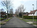
1
Rushley Close, Keston
Rushley Close is a short cul-de-sac in Keston, on the south-east fringe of London.
Image: © Malc McDonald
Taken: 31 Jul 2016
0.03 miles

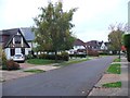
5
Beechwood Drive, Keston
Beechwood Drive in Keston, on the south-eastern fringe of Greater London.
Image: © Malc McDonald
Taken: 31 Jul 2016
0.08 miles
8
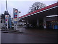
Esso garage on the corner of Westerham Road and Croydon Road
Image: © David Howard
Taken: 12 Feb 2012
0.10 miles
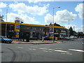
10
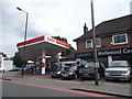
The White House Service Station, Keston
Next to Holwood Cars which may be connected
Image: © David Howard
Taken: 17 Aug 2015
0.11 miles