IMAGES TAKEN NEAR TO
Commonside, KESTON, BR2 6BS
Introduction
This page details the photographs taken nearby to Commonside, BR2 6BS by members of the Geograph project.
The Geograph project started in 2005 with the aim of publishing, organising and preserving representative images for every square kilometre of Great Britain, Ireland and the Isle of Man.

There are currently over 7.5m images from over14,400 individuals and you can help contribute to the project by visiting https://www.geograph.org.uk
Image Map
Images are licensed for reuse under creativecommons.org/licenses/by-sa/2.0
Notes
- Clicking on the map will re-center to the selected point.
- The higher the marker number, the further away the image location is from the centre of the postcode.
Image Listing (59 Images Found)
Images are licensed for reuse under creativecommons.org/licenses/by-sa/2.0
Image
Details
Distance
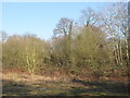
1
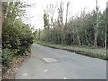
Commonside, Keston
In the middle of Hayes Common
Image: © David Howard
Taken: 12 Apr 2015
0.08 miles
3
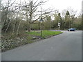
Commonside, Keston
Looking towards Croydon Road
Image: © David Howard
Taken: 12 Apr 2015
0.09 miles
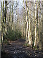
4
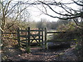
Kissing gate at the northwest corner of Padmall Wood
Image: © Mike Quinn
Taken: 17 Feb 2010
0.10 miles
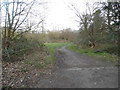
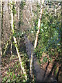
6
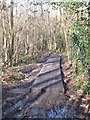
More duckboards in a damp part of Padmall Wood
Image: © Mike Quinn
Taken: 17 Feb 2010
0.13 miles
8

Keston Church
The view from Hayes Common of Keston Village.
Image: © Gordon Griffiths
Taken: 18 Oct 2009
0.14 miles
9
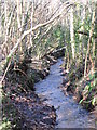
The River Ravensbourne in the north of Padmall Wood
Image: © Mike Quinn
Taken: 17 Feb 2010
0.14 miles
10
The River Ravensbourne in Padmall Wood (4)
Image: © Mike Quinn
Taken: 17 Feb 2010
0.15 miles