IMAGES TAKEN NEAR TO
Kingsleigh Walk, BROMLEY, BR2 0YE
Introduction
This page details the photographs taken nearby to Kingsleigh Walk, BR2 0YE by members of the Geograph project.
The Geograph project started in 2005 with the aim of publishing, organising and preserving representative images for every square kilometre of Great Britain, Ireland and the Isle of Man.

There are currently over 7.5m images from over14,400 individuals and you can help contribute to the project by visiting https://www.geograph.org.uk
Image Map
Images are licensed for reuse under creativecommons.org/licenses/by-sa/2.0
Notes
- Clicking on the map will re-center to the selected point.
- The higher the marker number, the further away the image location is from the centre of the postcode.
Image Listing (19 Images Found)
Images are licensed for reuse under creativecommons.org/licenses/by-sa/2.0
Image
Details
Distance
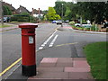
1
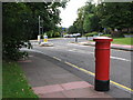
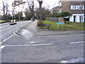
Westmoreland Road / Cumberland Road
Shows the location of Image
Image: © Mike Quinn
Taken: 20 Aug 2008
0.05 miles
2
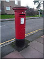
Bromley: postbox № BR2 15, Cumberland Road
One of few pillar boxes to be cast during the short reign of Edward VIII - there are 80 or so still in use. This one is in Cumberland Road, by the junction with Westmoreland Road, and it seems it has been moved here from further up the road since Mike Quinn photographed it in August 2008: see Image (A Victorian postbox previously stood on this spot - see Image)
Image: © Chris Downer
Taken: 18 Jan 2014
0.07 miles
3
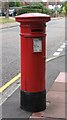
"Anonymous" (Victorian) postbox, Westmoreland Road / Cumberland Road
The position of the posting aperture dates this postbox to 1883-87. The location of this postbox is shown in Image and Image
Image: © Mike Quinn
Taken: 20 Aug 2008
0.08 miles
6
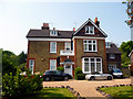
Bromley: 1, South Hill Park
Just off Westmoreland Road. Lovely large house - but even here, multi-occupied.
Image: © Dr Neil Clifton
Taken: 24 May 2012
0.16 miles
7
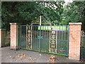
Gates to South Hill Wood
These cast iron gates and brick piers are on South Hill Road, close to the junction with Westmoreland Road.
They lead into a community garden and then around to a small woodland.
Image: © David Anstiss
Taken: 28 Aug 2011
0.18 miles
8
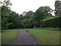
Path to South Hill Wood
A permissive path leads from South Hill Road, into a community garden and around to a small woodland.
Image: © David Anstiss
Taken: 28 Aug 2011
0.20 miles
9
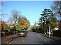
Durham Road Junction
Durham Road joins Westmoreland Road, Bromley.
Image: © Gordon Griffiths
Taken: 21 Jan 2009
0.20 miles
10
Tributary of the River Ravensbourne west of Cameron Road, BR2
Image: © Mike Quinn
Taken: 11 Jan 2011
0.21 miles