IMAGES TAKEN NEAR TO
Westmoreland Road, BROMLEY, BR2 0TR
Introduction
This page details the photographs taken nearby to Westmoreland Road, BR2 0TR by members of the Geograph project.
The Geograph project started in 2005 with the aim of publishing, organising and preserving representative images for every square kilometre of Great Britain, Ireland and the Isle of Man.

There are currently over 7.5m images from over14,400 individuals and you can help contribute to the project by visiting https://www.geograph.org.uk
Image Map
Images are licensed for reuse under creativecommons.org/licenses/by-sa/2.0
Notes
- Clicking on the map will re-center to the selected point.
- The higher the marker number, the further away the image location is from the centre of the postcode.
Image Listing (16 Images Found)
Images are licensed for reuse under creativecommons.org/licenses/by-sa/2.0
Image
Details
Distance
1
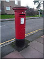
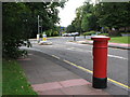
Bromley: postbox № BR2 15, Cumberland Road
One of few pillar boxes to be cast during the short reign of Edward VIII - there are 80 or so still in use. This one is in Cumberland Road, by the junction with Westmoreland Road, and it seems it has been moved here from further up the road since Mike Quinn photographed it in August 2008: see Image (A Victorian postbox previously stood on this spot - see Image)
Image: © Chris Downer
Taken: 18 Jan 2014
0.06 miles
2
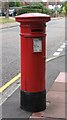
"Anonymous" (Victorian) postbox, Westmoreland Road / Cumberland Road
The position of the posting aperture dates this postbox to 1883-87. The location of this postbox is shown in Image and Image
Image: © Mike Quinn
Taken: 20 Aug 2008
0.08 miles
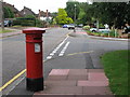
5
Westmoreland Road / Cumberland Road
Shows the location of Image
Image: © Mike Quinn
Taken: 20 Aug 2008
0.08 miles
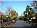
6
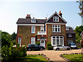
Bromley: 1, South Hill Park
Just off Westmoreland Road. Lovely large house - but even here, multi-occupied.
Image: © Dr Neil Clifton
Taken: 24 May 2012
0.15 miles
7
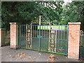
Gates to South Hill Wood
These cast iron gates and brick piers are on South Hill Road, close to the junction with Westmoreland Road.
They lead into a community garden and then around to a small woodland.
Image: © David Anstiss
Taken: 28 Aug 2011
0.17 miles
8
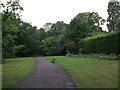
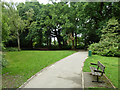
Path to South Hill Wood
A permissive path leads from South Hill Road, into a community garden and around to a small woodland.
Image: © David Anstiss
Taken: 28 Aug 2011
0.19 miles
9
Path, South Hill Wood
This public open space is mostly fairly dense woodland, apart from this area and by the eastern entrance.
Image: © Robin Webster
Taken: 18 Jun 2011
0.20 miles
10

South Hill Wood
South Hill Wood is a remnant of the semi-natural ancient woodland Toots Wood. It was purchased by Sir Thomas Dewey in 1887 and he built a large family residence with gardens of exotic and ornamental plants, sunken gardens and specimen trees, stables, a conservatory and a music pavilion. The gardens were at their peak between 1905 and 1914. Dewey was the Chair of Prudential Assurance Company and in 1903 was made Charter Mayor of Bromley. He lived at South Hill with his wife Clara and five children.
In 1926 the South Hill Wood residence was bought by Arthur Chilton King, manufacturer of Chilton Biscuits. In 1947 the Borough of Beckenham entered negotiations with Mr King to purchase the estate and create a public park. The negotiations were protracted and futile and in 1952 the Council compulsorily purchased the land and a public park was created and opened on 2nd May 1959. It included the remnants of Toots Wood, the old pond and features from Dewey's garden. Since 1959, the woodland cover has regenerated and the remains of the fountain and water feature can still be found.
Image: © Marathon
Taken: 9 Oct 2013
0.20 miles