IMAGES TAKEN NEAR TO
Winchester Park, BROMLEY, BR2 0PY
Introduction
This page details the photographs taken nearby to Winchester Park, BR2 0PY by members of the Geograph project.
The Geograph project started in 2005 with the aim of publishing, organising and preserving representative images for every square kilometre of Great Britain, Ireland and the Isle of Man.

There are currently over 7.5m images from over14,400 individuals and you can help contribute to the project by visiting https://www.geograph.org.uk
Image Map
Images are licensed for reuse under creativecommons.org/licenses/by-sa/2.0
Notes
- Clicking on the map will re-center to the selected point.
- The higher the marker number, the further away the image location is from the centre of the postcode.
Image Listing (53 Images Found)
Images are licensed for reuse under creativecommons.org/licenses/by-sa/2.0
Image
Details
Distance
1
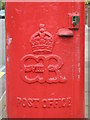
Edward VIII postbox, Cumberland Road / St Mary's Avenue - royal cipher
See Image
Image: © Mike Quinn
Taken: 20 Aug 2008
0.07 miles
2

Edward VIII postbox, Cumberland Road / St Mary's Avenue
Image: © Mike Quinn
Taken: 20 Aug 2008
0.07 miles
4
Cumberland Road / St Mary's Avenue
Shows the location of Image
Image: © Mike Quinn
Taken: 20 Aug 2008
0.09 miles
5

Width restriction on Hillside Road, near Bromley
This width restriction prevents large vehicles, such as lorries and buses, from using this residential road as a short-cut.
Image: © Malc McDonald
Taken: 31 Jul 2016
0.12 miles
6
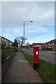
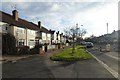
Postbox on Hillside Road
Looking along Hillside Road near Queen Anne Avenue.
Image: © DS Pugh
Taken: 8 Dec 2017
0.12 miles
7

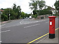
Northern end of Hillside Road
Looking across Hillside Road close to where it becomes Valley Road.
Image: © DS Pugh
Taken: 8 Dec 2017
0.12 miles
8
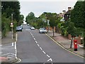
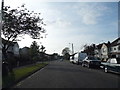
Traffic calming on Hillside Road
Looking along Hillside Road towards Queen Anne Avenue.
Image: © DS Pugh
Taken: 8 Dec 2017
0.12 miles
9
Queen Anne Avenue, Bromley
Heading for the width restriction. This road allows traffic to bypass the centre of Bromley for Bromley South and they clearly don't want lorries along it.
Image: © David Howard
Taken: 4 May 2014
0.13 miles
10
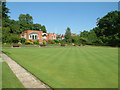
South Hill Wood Bowling Club BR2
South Hill Woods Tennis Club's courts are barely visible beyond the far corner of the green.
Image: © Philip Talmage
Taken: 31 Aug 2005
0.14 miles