IMAGES TAKEN NEAR TO
Tootswood Road, BROMLEY, BR2 0PD
Introduction
This page details the photographs taken nearby to Tootswood Road, BR2 0PD by members of the Geograph project.
The Geograph project started in 2005 with the aim of publishing, organising and preserving representative images for every square kilometre of Great Britain, Ireland and the Isle of Man.

There are currently over 7.5m images from over14,400 individuals and you can help contribute to the project by visiting https://www.geograph.org.uk
Image Map
Images are licensed for reuse under creativecommons.org/licenses/by-sa/2.0
Notes
- Clicking on the map will re-center to the selected point.
- The higher the marker number, the further away the image location is from the centre of the postcode.
Image Listing (45 Images Found)
Images are licensed for reuse under creativecommons.org/licenses/by-sa/2.0
Image
Details
Distance
6
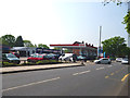
Bromley: Esso filling station and Tesco Extra, Westmoreland Road
Solid blue-voting wall-to-wall posh suburbia round here. But they can't spell 'Westmorland' properly.
Image: © Dr Neil Clifton
Taken: 24 May 2012
0.10 miles
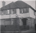
8
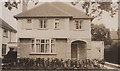
Mapperley, Romanhurst Avenue, Bromley BR2 0PF
My grandparents lived here after the second world war until 1963.
Image: © Ronald Frederick Harvey
Taken: Unknown
0.11 miles
9
Mapperley, Romanhurst Avenue, Bromley BR2 0PF
My grandparents lived here post WWII until 1963.
Image: © David Harvey
Taken: Unknown
0.11 miles
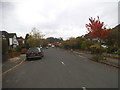
10
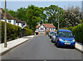
Bromley: Romanhurst Avenue
Cul-de-sac off Tootswood Road
Image: © Dr Neil Clifton
Taken: 24 May 2012
0.11 miles