IMAGES TAKEN NEAR TO
Shortlands Road, BROMLEY, BR2 0JL
Introduction
This page details the photographs taken nearby to Shortlands Road, BR2 0JL by members of the Geograph project.
The Geograph project started in 2005 with the aim of publishing, organising and preserving representative images for every square kilometre of Great Britain, Ireland and the Isle of Man.

There are currently over 7.5m images from over14,400 individuals and you can help contribute to the project by visiting https://www.geograph.org.uk
Image Map
Images are licensed for reuse under creativecommons.org/licenses/by-sa/2.0
Notes
- Clicking on the map will re-center to the selected point.
- The higher the marker number, the further away the image location is from the centre of the postcode.
Image Listing (30 Images Found)
Images are licensed for reuse under creativecommons.org/licenses/by-sa/2.0
Image
Details
Distance
1
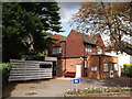
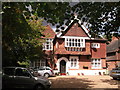
Shortlands Library
A converted house into library on Shortlands Road.
Image: © David Anstiss
Taken: 28 Aug 2011
0.03 miles
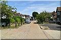
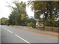
2
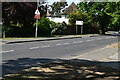
Den Road Bus Stop
The view down Shortlands Road towards Hayes Lane.
Image: © Gordon Griffiths
Taken: 25 Jul 2011
0.03 miles
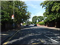
4
No 114 Shortlands Road
Grade II listed building, has been converted into three flats.
Image: © David Anstiss
Taken: 28 Aug 2011
0.07 miles