IMAGES TAKEN NEAR TO
Oakbrook Close, BROMLEY, BR1 5RY
Introduction
This page details the photographs taken nearby to Oakbrook Close, BR1 5RY by members of the Geograph project.
The Geograph project started in 2005 with the aim of publishing, organising and preserving representative images for every square kilometre of Great Britain, Ireland and the Isle of Man.

There are currently over 7.5m images from over14,400 individuals and you can help contribute to the project by visiting https://www.geograph.org.uk
Image Map
Images are licensed for reuse under creativecommons.org/licenses/by-sa/2.0
Notes
- Clicking on the map will re-center to the selected point.
- The higher the marker number, the further away the image location is from the centre of the postcode.
Image Listing (122 Images Found)
Images are licensed for reuse under creativecommons.org/licenses/by-sa/2.0
Image
Details
Distance

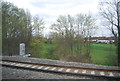
4

Approaching Grove Park Station
An unidentified class 73 Electro-Diesel approaches the station with two carriages from a 4-VEP electric unit which presumably are in need of maintenance. This is the mainline to Orpington and Kent, whilst the tracks branching off to the right go to Bromley North.
Image: © Martin Addison
Taken: Unknown
0.07 miles
5

Approaching Grove Park
Class 465, 465013, approaches Grove Park with the 2F29 Orpington to Cannon Street service.
Image: © Martin Addison
Taken: 18 Nov 2021
0.08 miles