IMAGES TAKEN NEAR TO
Kevin Fenton Mews, BR1 5FF
Introduction
This page details the photographs taken nearby to Kevin Fenton Mews, BR1 5FF by members of the Geograph project.
The Geograph project started in 2005 with the aim of publishing, organising and preserving representative images for every square kilometre of Great Britain, Ireland and the Isle of Man.

There are currently over 7.5m images from over14,400 individuals and you can help contribute to the project by visiting https://www.geograph.org.uk
Image Map
Images are licensed for reuse under creativecommons.org/licenses/by-sa/2.0
Notes
- Clicking on the map will re-center to the selected point.
- The higher the marker number, the further away the image location is from the centre of the postcode.
Image Listing (62 Images Found)
Images are licensed for reuse under creativecommons.org/licenses/by-sa/2.0
Image
Details
Distance
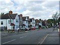
1
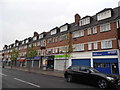
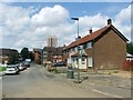
Shops on Burnt Ash Lane, Plaistow
Without planning it I went to both Plaistows today, this one and the one in West Ham, which I think was my first time in the second one.
Image: © David Howard
Taken: 27 Apr 2014
0.02 miles
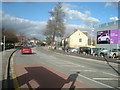
2
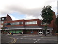
Burnt Ash Waitrose Supermarket
On Burnt Ash Lane, opposite Milk Street.
Image: © David Anstiss
Taken: 18 Sep 2011
0.04 miles
3
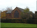
St Andrew's Church, Burnt Ash Lane, Bromley
The rear of the church seen from Kings Meadow Image The building dates from 1929 by architect (later Sir) Charles Nicholson. It is less grand than some of his other South London churches such as St John's Catford Image
Image: © Stephen Craven
Taken: 29 Nov 2013
0.07 miles
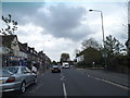
4
Milk Street
Milk Street was built in 1962-63
Image: © Ashley Martin
Taken: 5 Feb 2012
0.08 miles
5
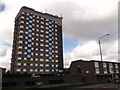
Burnt Ash Heights and Wells House, Burnt Ash
Tower block of housing on Burnt Ash Lane.
Image: © David Anstiss
Taken: 18 Sep 2011
0.08 miles
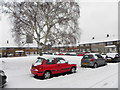
10
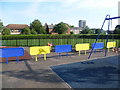
Playground at King's Meadow Playing Fields
The playground is at the north end of King's Meadow Playing Fields, situated between Burnt Ash Lane and the railway from Grove Park to Sundridge Park. The church beyond is St Andrew's in Burnt Ash Lane, and to the left of that is Sundridge Park Working Men's Club.
Image: © Marathon
Taken: 15 Jul 2011
0.11 miles