IMAGES TAKEN NEAR TO
Milverton Place, BROMLEY, BR1 5FB
Introduction
This page details the photographs taken nearby to Milverton Place, BR1 5FB by members of the Geograph project.
The Geograph project started in 2005 with the aim of publishing, organising and preserving representative images for every square kilometre of Great Britain, Ireland and the Isle of Man.

There are currently over 7.5m images from over14,400 individuals and you can help contribute to the project by visiting https://www.geograph.org.uk
Image Map
Images are licensed for reuse under creativecommons.org/licenses/by-sa/2.0
Notes
- Clicking on the map will re-center to the selected point.
- The higher the marker number, the further away the image location is from the centre of the postcode.
Image Listing (61 Images Found)
Images are licensed for reuse under creativecommons.org/licenses/by-sa/2.0
Image
Details
Distance

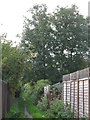
3
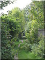
Footpath between Portland Road and Leamington Avenue, BR1 (3)
This path lies on the line of the Quaggy River - see the satellite image http://wtp2.appspot.com/wheresthepath.htm?lat=51.4259320504206&lon=0.02765658106940503&gz=19&oz=10>=1.
Image: © Mike Quinn
Taken: 12 Oct 2010
0.08 miles
4
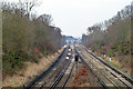
Railway towards Grove Park
The main Charing Cross - Dover line, viewed from bridge XTD 141.
Image: © Robin Webster
Taken: 4 Feb 2012
0.08 miles
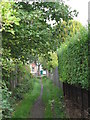
5

Footpath between Portland Road and Leamington Avenue, BR1 (4)
This path lies on the line of the Quaggy River - see the satellite image http://wtp2.appspot.com/wheresthepath.htm?lat=51.4259320504206&lon=0.02765658106940503&gz=19&oz=10>=1.
Image: © Mike Quinn
Taken: 12 Oct 2010
0.09 miles
6
Footpath between Portland Road and Leamington Avenue, BR1
This path is on the line of the Quaggy River south of Image - see the satellite image http://wtp2.appspot.com/wheresthepath.htm?lat=51.42484840686741&lon=0.028002262115478515&gz=17&oz=9>=1.
Image: © Mike Quinn
Taken: 12 Oct 2010
0.09 miles
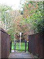
7
Footpath between Portland Road and Leamington Avenue, BR1 (2)
This path is on the line of the Quaggy River south of Image - see the satellite image http://wtp2.appspot.com/wheresthepath.htm?lat=51.42484840686741&lon=0.028002262115478515&gz=17&oz=9>=1.
Image: © Mike Quinn
Taken: 12 Oct 2010
0.10 miles
8
Footpath at the southern end of Chinbrook Meadows
Image: © Mike Quinn
Taken: 12 Oct 2010
0.11 miles