IMAGES TAKEN NEAR TO
Moorside Road, BROMLEY, BR1 5EY
Introduction
This page details the photographs taken nearby to Moorside Road, BR1 5EY by members of the Geograph project.
The Geograph project started in 2005 with the aim of publishing, organising and preserving representative images for every square kilometre of Great Britain, Ireland and the Isle of Man.

There are currently over 7.5m images from over14,400 individuals and you can help contribute to the project by visiting https://www.geograph.org.uk
Image Map
Images are licensed for reuse under creativecommons.org/licenses/by-sa/2.0
Notes
- Clicking on the map will re-center to the selected point.
- The higher the marker number, the further away the image location is from the centre of the postcode.
Image Listing (31 Images Found)
Images are licensed for reuse under creativecommons.org/licenses/by-sa/2.0
Image
Details
Distance
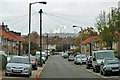
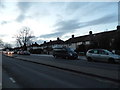
1
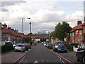
Moorside Road, Downham
This road leads from Downham Way towards Whitefoot Lane.
It gives a view of the Isle of Dogs tower blocks, including Canary Wharf.
Image: © David Anstiss
Taken: 18 Sep 2011
0.02 miles
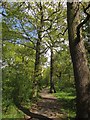
2
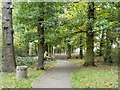
Path from Downderry Road to Moorside Road
Running along a belt of woodland, it is part of the 'Green Chain' long distance London walk. The route continues on the other side of Moorside Road.
Image: © Robin Webster
Taken: 30 Oct 2011
0.05 miles
3
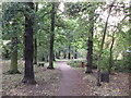
Downham Woodlands Walk (2)
This woodland walk is a long narrow strip of ancient woodland that runs for nearly a mile through the Downham Estate. This section is between Moorside Road and Downderry Road.
It is part of the Green Chain Walk (long distance walk) and it contains some magnificent old oak and ash trees.
Image: © David Anstiss
Taken: 18 Sep 2011
0.05 miles
4
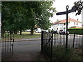
Green Chain Walk on Woodside Road
The long distance path leads along the Downham Woodland Walk (within the Downham housing estate). The path leads along Undershaw Road towards Woodbank Road. Shaw Road is the other side of the green (in the background).
Image: © David Anstiss
Taken: 18 Sep 2011
0.05 miles
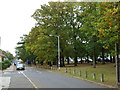
5
Moorside Road
A good view of the London Docklands tower blocks.
Image: © Robin Webster
Taken: 30 Oct 2011
0.06 miles
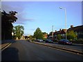
6
Undershaw Road
The parallel road on the other side of the trees is Shaw Road. Are the trees the shaw concerned?
Image: © Robin Webster
Taken: 30 Oct 2011
0.07 miles
8

Green Chain Walk, Downham
The Walk, and the Capital Ring, runs past these lovely spring trees down the central area between Undershaw Road (left) and Shaw Road.
Image: © Derek Harper
Taken: 9 May 2013
0.09 miles
9
Downham Woodland Walk
Image: © Derek Harper
Taken: 9 May 2013
0.09 miles
10
Whitefoot Lane, Southend
This is the Southend in Bromley (it's in the borough of Lewisham but a quarter of Bromley is) not Southend on Sea.
Image: © David Howard
Taken: 16 Feb 2014
0.09 miles