IMAGES TAKEN NEAR TO
Downham Way, BROMLEY, BR1 5EN
Introduction
This page details the photographs taken nearby to Downham Way, BR1 5EN by members of the Geograph project.
The Geograph project started in 2005 with the aim of publishing, organising and preserving representative images for every square kilometre of Great Britain, Ireland and the Isle of Man.

There are currently over 7.5m images from over14,400 individuals and you can help contribute to the project by visiting https://www.geograph.org.uk
Image Map
Images are licensed for reuse under creativecommons.org/licenses/by-sa/2.0
Notes
- Clicking on the map will re-center to the selected point.
- The higher the marker number, the further away the image location is from the centre of the postcode.
Image Listing (39 Images Found)
Images are licensed for reuse under creativecommons.org/licenses/by-sa/2.0
Image
Details
Distance
1
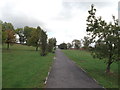
Cyclepath to Downham Heath and Leisure Centre
This path leads from Downham Way, up through Downham Fields.
Image: © David Anstiss
Taken: 18 Sep 2011
0.06 miles
2
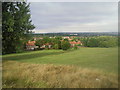
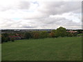
View from Downham Fields
The most impressive feature of Downham Fields is the view. This photograph looks towards the Crystal Palace Ridge, with the South Norwood and the Crystal Palace TV masts on the skyline. Left of centre, the white building in the trees is Beckenham Place house.
Image: © Marathon
Taken: 20 Aug 2010
0.09 miles
3

Downham Health and Leisure Centre (2)
This building is a community health, leisure and well-being private finance initiative (PFI) facility which opened in March 2007. It has a range of facilities including a 25m swimming pool, learner pool, fitness suite, badminton court, dance and activity studios, library with associated meeting area and dedicated ICT spaces, exhibition space, café, creche, an Accesspoint for council services, community hall, two GP surgeries, community health care facilities and a dental practice.
It replaced a smaller library and local baths.
Seen from Downham Fields.
Image: © David Anstiss
Taken: 18 Sep 2011
0.11 miles
4

Downham Fields Panorama
Looking across the Sydenham and West Norwood region of London.
Crystal Palace tower can be seen in the middle.
Image: © David Anstiss
Taken: 18 Sep 2011
0.12 miles
5
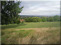
Downham Fields
Downham Fields is a valuable open space for the Downham Estate. It also provides fine views to the west as seen here.
Image: © Marathon
Taken: 20 Aug 2010
0.13 miles
6

Downham Health and Leisure Centre
This building is a community health, leisure and well-being private finance initiative (PFI) facility which opened in March 2007. It has a range of facilities including a 25m swimming pool, learner pool, fitness suite, badminton court, dance and activity studios, library with associated meeting area and dedicated ICT spaces, exhibition space, café, creche, an Accesspoint for council services, community hall, two GP surgeries, community health care facilities and a dental practice.
It replaced a smaller library and local baths.
Image: © David Anstiss
Taken: 18 Sep 2011
0.14 miles

8
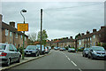
Southover
One of those roads whose name does not immediately identify it as a road.
Image: © Robin Webster
Taken: 30 Oct 2011
0.15 miles
9
View from Downham Fields
Looking towards Crystal Palace TV Tower.
On the right is construction crane near New Woodlands School.
Image: © David Anstiss
Taken: 18 Sep 2011
0.17 miles
10
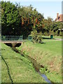
The River Ravensbourne - Downham Branch, Shaftesbury Park (3)
Image: © Mike Quinn
Taken: 8 Oct 2009
0.20 miles