IMAGES TAKEN NEAR TO
Ivorydown, BROMLEY, BR1 5EJ
Introduction
This page details the photographs taken nearby to Ivorydown, BR1 5EJ by members of the Geograph project.
The Geograph project started in 2005 with the aim of publishing, organising and preserving representative images for every square kilometre of Great Britain, Ireland and the Isle of Man.

There are currently over 7.5m images from over14,400 individuals and you can help contribute to the project by visiting https://www.geograph.org.uk
Image Map
Images are licensed for reuse under creativecommons.org/licenses/by-sa/2.0
Notes
- Clicking on the map will re-center to the selected point.
- The higher the marker number, the further away the image location is from the centre of the postcode.
Image Listing (70 Images Found)
Images are licensed for reuse under creativecommons.org/licenses/by-sa/2.0
Image
Details
Distance
1
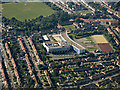
Haberdashers' Aske's Knights Academy from the air
Located in Bromley, viewed from a flight from Glasgow to London City.
School web site: https://www.habsknights.org.uk/ .
Image: © Thomas Nugent
Taken: 26 Aug 2019
0.06 miles
2

The King's Church, Grove Park
Church on a sloped piece of ground between Ballamore Road and Downham Way.
Image: © David Anstiss
Taken: 18 Sep 2011
0.09 miles
3

Bromley from the air
Haberdashers' Aske's Knights Academy is prominent.
School web site: https://www.habsknights.org.uk/ .
Image: © Thomas Nugent
Taken: 26 Aug 2019
0.10 miles
5
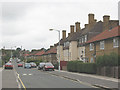
Downham Estate
Downham Estate is a large housing estate developed in the 1920s by the London County Council. The estate was built to ease a housing shortage which existed then. This view looks east along Shroffold Road.
Image: © Malc McDonald
Taken: 25 May 2011
0.15 miles
6
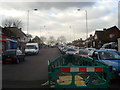
Shroffold Road
Most of the housing on this road consists of pairs of semi-detached houses or short two-storey terraces, typical of the area, but there is this one larger three-storey block of flats in a quite different style.
Image: © Stephen Craven
Taken: 26 Aug 2010
0.16 miles
7

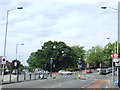
View along Downham Way towards Grove Park station
Image: © David Martin
Taken: 13 Jul 2014
0.17 miles
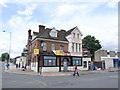
8
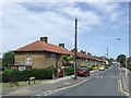
Downham Way/Northover junction
The junction of Downham Way and Northover, near Grove Park in South East London.
This area was developed in the 1920s by the London County Council, as part of the Downham Estate. The estate was built to ease a serious housing shortage which existed at the time.
Image: © Malc McDonald
Taken: 25 May 2011
0.18 miles
10

Grove Park: postbox № SE12 4, Baring Road
The fact that this Victorian postbox is a large one suggests that it is outside the former location of Grove Park Post Office. The current office is a short distance up, on the other side of the road, with no box outside.
Image: © Chris Downer
Taken: 29 Sep 2013
0.18 miles