IMAGES TAKEN NEAR TO
Launcelot Road, BROMLEY, BR1 5DZ
Introduction
This page details the photographs taken nearby to Launcelot Road, BR1 5DZ by members of the Geograph project.
The Geograph project started in 2005 with the aim of publishing, organising and preserving representative images for every square kilometre of Great Britain, Ireland and the Isle of Man.

There are currently over 7.5m images from over14,400 individuals and you can help contribute to the project by visiting https://www.geograph.org.uk
Image Map
Images are licensed for reuse under creativecommons.org/licenses/by-sa/2.0
Notes
- Clicking on the map will re-center to the selected point.
- The higher the marker number, the further away the image location is from the centre of the postcode.
Image Listing (17 Images Found)
Images are licensed for reuse under creativecommons.org/licenses/by-sa/2.0
Image
Details
Distance
1
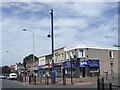
Downham Way shops
A parade of local shops in Downham Way in South East London.
Image: © Malc McDonald
Taken: 25 May 2011
0.09 miles
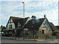
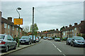
2
Downham Way & the Downham Tavern, BR1
Looking north. This was the centre of the huge municipal housing estate opened by the London County Council in 1928. The pub dates from 1930, when it was built as the only public house for an area with a population approaching 30,000.
Image: © Philip Talmage
Taken: 4 Nov 2005
0.10 miles
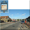
4

Downham Way passes the shops
The bus is on route 136 bound for Peckham.
Image: © Robin Webster
Taken: 30 Oct 2011
0.13 miles
5

Downham Tavern, Downham
At the junction of Downham Way (in front) and Capstone Road (behind the pub).
Not much change since Image (in 2005).
Image: © David Anstiss
Taken: 18 Sep 2011
0.13 miles
6
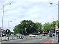
Downham Way/Northover junction
The junction of Downham Way and Northover, near Grove Park in South East London.
This area was developed in the 1920s by the London County Council, as part of the Downham Estate. The estate was built to ease a serious housing shortage which existed at the time.
Image: © Malc McDonald
Taken: 25 May 2011
0.13 miles

8
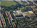
Haberdashers' Aske's Knights Academy from the air
Located in Bromley, viewed from a flight from Glasgow to London City.
School web site: https://www.habsknights.org.uk/ .
Image: © Thomas Nugent
Taken: 26 Aug 2019
0.16 miles
9

Downham Health and Leisure Centre
This building is a community health, leisure and well-being private finance initiative (PFI) facility which opened in March 2007. It has a range of facilities including a 25m swimming pool, learner pool, fitness suite, badminton court, dance and activity studios, library with associated meeting area and dedicated ICT spaces, exhibition space, café, creche, an Accesspoint for council services, community hall, two GP surgeries, community health care facilities and a dental practice.
It replaced a smaller library and local baths.
Image: © David Anstiss
Taken: 18 Sep 2011
0.17 miles
10
Southover
One of those roads whose name does not immediately identify it as a road.
Image: © Robin Webster
Taken: 30 Oct 2011
0.20 miles