IMAGES TAKEN NEAR TO
Milk Street, BROMLEY, BR1 5AG
Introduction
This page details the photographs taken nearby to Milk Street, BR1 5AG by members of the Geograph project.
The Geograph project started in 2005 with the aim of publishing, organising and preserving representative images for every square kilometre of Great Britain, Ireland and the Isle of Man.

There are currently over 7.5m images from over14,400 individuals and you can help contribute to the project by visiting https://www.geograph.org.uk
Image Map
Images are licensed for reuse under creativecommons.org/licenses/by-sa/2.0
Notes
- Clicking on the map will re-center to the selected point.
- The higher the marker number, the further away the image location is from the centre of the postcode.
Image Listing (91 Images Found)
Images are licensed for reuse under creativecommons.org/licenses/by-sa/2.0
Image
Details
Distance
1
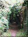
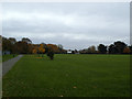
Footpath south of Hall's Farm
The path is part of the Green Chain Walk - see http://www.greenchain.com/walking.php.
Image: © Mike Quinn
Taken: 12 Oct 2010
0.04 miles
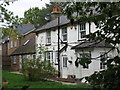
3
Halls Farm House
At the end of Milk Street.
Image: © David Anstiss
Taken: 18 Sep 2011
0.04 miles
6
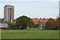
Kings Meadow, Bromley
A public open space north of the town centre. The path on the left of the photo is part of the signed cycle route from Lee to Bromley.
Image: © Stephen Craven
Taken: 29 Nov 2013
0.08 miles
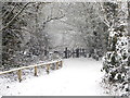
7
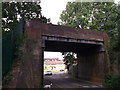
Railway Bridge over Milk Street
Milk Street Leads from Hall Farm towards Bunrt Ash Lane.
The bridge carries the line between Sundridge Park and Grove Park.
Image: © David Anstiss
Taken: 18 Sep 2011
0.08 miles
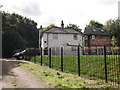
8
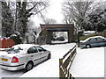
Railway Bridge over Milk Street
The bridge carries the line between Sundridge Park and Grove Park.
Milk Street Side
Image: © Ashley Martin
Taken: 5 Feb 2012
0.08 miles
9
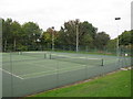
Tennis courts at the Sundridge Park Lawn Tennis & Squash Rackets Club
Image: © Mike Quinn
Taken: 12 Oct 2010
0.08 miles
10
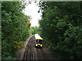
Railway lines north of Minster Road, BR1
Image: © Mike Quinn
Taken: 12 Oct 2010
0.09 miles