IMAGES TAKEN NEAR TO
Belgravia Gardens, BROMLEY, BR1 4TS
Introduction
This page details the photographs taken nearby to Belgravia Gardens, BR1 4TS by members of the Geograph project.
The Geograph project started in 2005 with the aim of publishing, organising and preserving representative images for every square kilometre of Great Britain, Ireland and the Isle of Man.

There are currently over 7.5m images from over14,400 individuals and you can help contribute to the project by visiting https://www.geograph.org.uk
Image Map
Images are licensed for reuse under creativecommons.org/licenses/by-sa/2.0
Notes
- Clicking on the map will re-center to the selected point.
- The higher the marker number, the further away the image location is from the centre of the postcode.
Image Listing (71 Images Found)
Images are licensed for reuse under creativecommons.org/licenses/by-sa/2.0
Image
Details
Distance
2
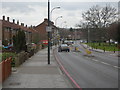
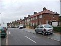
Bromley Hill
This is the A21, the road between Lewisham and Bromley.
Image: © Danny P Robinson
Taken: 25 Feb 2007
0.09 miles
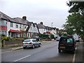
3
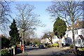
The view down Coniston Road
From outside the Bromley Court Hotel.
Image: © Stanley Howe
Taken: 21 Feb 2009
0.10 miles
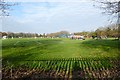
6
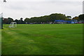
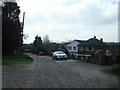
Millwall FC Training Ground
Known as the Calmont Road ground.
Image: © Bill Boaden
Taken: 10 Oct 2015
0.13 miles
7

Cemetery chapel near Bromley
The chapel in a small cemetery near Bromley in South East London.
Image: © Malc McDonald
Taken: 25 May 2011
0.14 miles
8
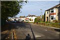
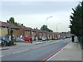
Calmont Road
Looking along Calmont Road at the junction with Hill Brow Road.
Image: © DS Pugh
Taken: 29 Nov 2014
0.14 miles
10
Football match
Sticking the camera through the fence of the path over the sports ground.
Image: © DS Pugh
Taken: 29 Nov 2014
0.16 miles