IMAGES TAKEN NEAR TO
Sissinghurst Close, BROMLEY, BR1 4SN
Introduction
This page details the photographs taken nearby to Sissinghurst Close, BR1 4SN by members of the Geograph project.
The Geograph project started in 2005 with the aim of publishing, organising and preserving representative images for every square kilometre of Great Britain, Ireland and the Isle of Man.

There are currently over 7.5m images from over14,400 individuals and you can help contribute to the project by visiting https://www.geograph.org.uk
Image Map
Images are licensed for reuse under creativecommons.org/licenses/by-sa/2.0
Notes
- Clicking on the map will re-center to the selected point.
- The higher the marker number, the further away the image location is from the centre of the postcode.
Image Listing (73 Images Found)
Images are licensed for reuse under creativecommons.org/licenses/by-sa/2.0
Image
Details
Distance
1
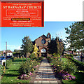
St Barnabas, Downham Way BR1
The church was built in 1929 as a traditional basilica in plain Early Christian Style.
Image: © Philip Talmage
Taken: 4 Nov 2005
0.08 miles
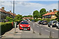
4
Downham Estate
A view along Keedonwood Road in Downham. Downham Estate was developed in the 1920s by the London County Council, to ease a housing shortage which existed at the time.
Image: © Malc McDonald
Taken: 25 May 2011
0.10 miles
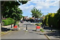
5
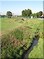
The River Ravensbourne - Downham Branch, east of Glenbow Road, BR1 (3)
Image: © Mike Quinn
Taken: 8 Oct 2009
0.11 miles
6
The River Ravensbourne - Downham Branch, east of Glenbow Road, BR1 (2)
Image: © Mike Quinn
Taken: 8 Oct 2009
0.11 miles
7

St Barnabas, Downham Way, Bromley, Kent - Sanctuary
Image: © John Salmon
Taken: 15 Dec 2008
0.11 miles
8
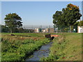
The River Ravensbourne - Downham Branch, west of Glenbow Road, BR1
Image: © Mike Quinn
Taken: 8 Oct 2009
0.11 miles
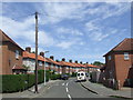
9
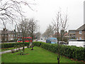
Garden of St Barnabas church, Downham
This is a view away from the parish church of St Barnabas, looking west (downhill) along Downham Way. The road is the spine of the large LCC housing estate developed in the 1920s/1930s. The area in front of the church has been developed as a community garden.
For photos of the church itself see http://www.geograph.org.uk/search.php?i=10367507
Image: © Stephen Craven
Taken: 25 Jan 2010
0.11 miles
10
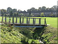
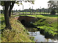
Footbridge over the River Ravensbourne - Downham Branch, east of Glenbow Road, BR1
Image: © Mike Quinn
Taken: 8 Oct 2009
0.11 miles