IMAGES TAKEN NEAR TO
Kinnaird Avenue, BROMLEY, BR1 4HG
Introduction
This page details the photographs taken nearby to Kinnaird Avenue, BR1 4HG by members of the Geograph project.
The Geograph project started in 2005 with the aim of publishing, organising and preserving representative images for every square kilometre of Great Britain, Ireland and the Isle of Man.

There are currently over 7.5m images from over14,400 individuals and you can help contribute to the project by visiting https://www.geograph.org.uk
Image Map
Images are licensed for reuse under creativecommons.org/licenses/by-sa/2.0
Notes
- Clicking on the map will re-center to the selected point.
- The higher the marker number, the further away the image location is from the centre of the postcode.
Image Listing (31 Images Found)
Images are licensed for reuse under creativecommons.org/licenses/by-sa/2.0
Image
Details
Distance
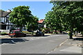
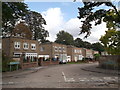
2
Park Avenue at Kinnaird Avenue
Forming part of the Green Chain walk.
Image: © DS Pugh
Taken: 29 Nov 2014
0.08 miles
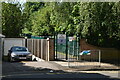
5
Kinnaird Close
Small close of houses, leading of the unadopted Kinnaird Avenue.
Image: © David Anstiss
Taken: 18 Sep 2011
0.10 miles
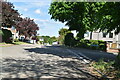
7
Along Park Avenue
Forming part of the Green Chain walk.
Image: © DS Pugh
Taken: 29 Nov 2014
0.11 miles
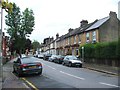
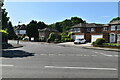
9
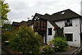
Suburban houses, Park Avenue, Plaistow, Bromley
Image: © Christopher Hilton
Taken: 30 Jul 2015
0.12 miles
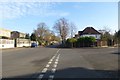
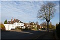
10
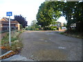
Kinnaird Avenue, Plaistow
A number of roads in Beckenham and Bromley are not made up. Kinnaird Avenue in Plaistow is one of them. It is seen from the Green Chain Walk which here follows Park Avenue
Image: © Marathon
Taken: 19 Aug 2011
0.12 miles