IMAGES TAKEN NEAR TO
Avondale Road, BROMLEY, BR1 4EP
Introduction
This page details the photographs taken nearby to Avondale Road, BR1 4EP by members of the Geograph project.
The Geograph project started in 2005 with the aim of publishing, organising and preserving representative images for every square kilometre of Great Britain, Ireland and the Isle of Man.

There are currently over 7.5m images from over14,400 individuals and you can help contribute to the project by visiting https://www.geograph.org.uk
Image Map
Images are licensed for reuse under creativecommons.org/licenses/by-sa/2.0
Notes
- Clicking on the map will re-center to the selected point.
- The higher the marker number, the further away the image location is from the centre of the postcode.
Image Listing (42 Images Found)
Images are licensed for reuse under creativecommons.org/licenses/by-sa/2.0
Image
Details
Distance
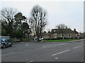
1
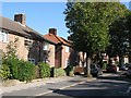
Brook Lane
The Downham Branch of the River Ravensbourne starts just to the west of the bottom of this road.
Image: © Mike Quinn
Taken: 8 Oct 2009
0.06 miles
2
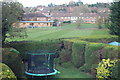
Sports Ground behind Avondale Road
Cricket ground next to Shaftesbury Park with houses on Rangefield Road behind and gardens of houses in Avondale Road in the foreground.
Image: © M J Roscoe
Taken: 9 Nov 2017
0.11 miles
3
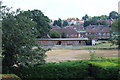
Cricket outfield, Rangefield Road
Pavilion and part of heatwave scorched field viewed from Avondale House.
Image: © M J Roscoe
Taken: 21 Jul 2018
0.12 miles
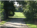
4
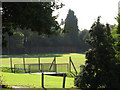
Footbridge over the River Ravensbourne - Downham Branch, Shaftesbury Park
Image: © Mike Quinn
Taken: 8 Oct 2009
0.12 miles
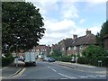
5
Brook Lane, Downham
Brook Lane is a road in the sprawling Downham estate, in the suburbs of south east London. The estate was built in the 1920s.
This image was taken on a dull and gloomy January day. As it was winter, the trees were bare.
Image: © Malc McDonald
Taken: 15 Jan 2022
0.13 miles
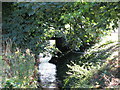
6
Entrance to the sports ground east of Shaftesbury Park
The Downham Branch of the River Ravensbourne runs left to right in front of the wire fence in the centre of the image.
Image: © Mike Quinn
Taken: 8 Oct 2009
0.13 miles
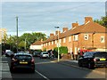
10
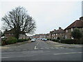
Southover, Downham
Southover is a road through part of the Downham estate, a large housing estate built in the 1920s in the suburbs of south east London.
This image was taken on a dull and gloomy January afternoon. The trees were bare for the winter.
Image: © Malc McDonald
Taken: 15 Jan 2022
0.16 miles