IMAGES TAKEN NEAR TO
Burnt Ash Lane, BROMLEY, BR1 4DH
Introduction
This page details the photographs taken nearby to Burnt Ash Lane, BR1 4DH by members of the Geograph project.
The Geograph project started in 2005 with the aim of publishing, organising and preserving representative images for every square kilometre of Great Britain, Ireland and the Isle of Man.

There are currently over 7.5m images from over14,400 individuals and you can help contribute to the project by visiting https://www.geograph.org.uk
Image Map
Images are licensed for reuse under creativecommons.org/licenses/by-sa/2.0
Notes
- Clicking on the map will re-center to the selected point.
- The higher the marker number, the further away the image location is from the centre of the postcode.
Image Listing (105 Images Found)
Images are licensed for reuse under creativecommons.org/licenses/by-sa/2.0
Image
Details
Distance
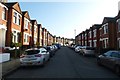
3
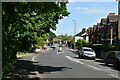
Park Avenue, near Bromley
Park Avenue is a residential road near Bromley, in the outer suburbs of south east London. It forms part of the route of the Green Chain Walk, indicated by the green signpost to the very left of the image.
This image was taken on a dull and gloomy January afternoon. Trees were bare for the winter.
Image: © Malc McDonald
Taken: 15 Jan 2022
0.03 miles
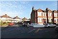
4
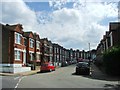
Croft Road
From the junction with Foxbury Road.
Image: © DS Pugh
Taken: 29 Nov 2014
0.03 miles
6
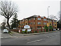
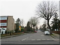
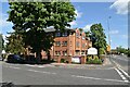
Park Avenue Care Home, near Bromley
Park Avenue Care Home is a residential nursing home near Bromley in the outer suburbs of south east London.
This image was taken on a dull and gloomy January afternoon. Trees were bare for the winter.
Image: © Malc McDonald
Taken: 15 Jan 2022
0.05 miles
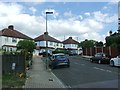
7
Foxbury Road
Forming part of the Green Chain walk.
Image: © DS Pugh
Taken: 29 Nov 2014
0.05 miles
9
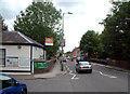
Plaistow Lane by Sundridge Park station BR1
Looking west past Sundridge Park station. The station is on a short branch line from Grove Park to Bromley North, and is the only intermediate station on the branch.
Image: © Philip Talmage
Taken: 25 Aug 2005
0.07 miles