IMAGES TAKEN NEAR TO
Plaistow Lane, BROMLEY, BR1 3TH
Introduction
This page details the photographs taken nearby to Plaistow Lane, BR1 3TH by members of the Geograph project.
The Geograph project started in 2005 with the aim of publishing, organising and preserving representative images for every square kilometre of Great Britain, Ireland and the Isle of Man.

There are currently over 7.5m images from over14,400 individuals and you can help contribute to the project by visiting https://www.geograph.org.uk
Image Map
Images are licensed for reuse under creativecommons.org/licenses/by-sa/2.0
Notes
- Clicking on the map will re-center to the selected point.
- The higher the marker number, the further away the image location is from the centre of the postcode.
Image Listing (107 Images Found)
Images are licensed for reuse under creativecommons.org/licenses/by-sa/2.0
Image
Details
Distance
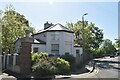
4
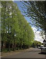
Trees on Garden Road, Bromley
The road is curving to meet Plaistow Lane close to Sundridge Park station.
Image: © Derek Harper
Taken: 9 May 2013
0.06 miles
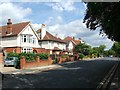

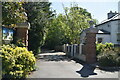
8
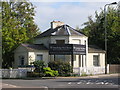
The lodge of Sundridge Park Manor, Willoughby Lane off Plaistow Lane, BR1
Image: © Mike Quinn
Taken: 12 Oct 2010
0.07 miles