IMAGES TAKEN NEAR TO
College Road, BROMLEY, BR1 3PT
Introduction
This page details the photographs taken nearby to College Road, BR1 3PT by members of the Geograph project.
The Geograph project started in 2005 with the aim of publishing, organising and preserving representative images for every square kilometre of Great Britain, Ireland and the Isle of Man.

There are currently over 7.5m images from over14,400 individuals and you can help contribute to the project by visiting https://www.geograph.org.uk
Image Map
Images are licensed for reuse under creativecommons.org/licenses/by-sa/2.0
Notes
- Clicking on the map will re-center to the selected point.
- The higher the marker number, the further away the image location is from the centre of the postcode.
Image Listing (102 Images Found)
Images are licensed for reuse under creativecommons.org/licenses/by-sa/2.0
Image
Details
Distance
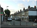
1
College Road, Bromley
The A2212 at the junction with Hammelton Road.
Image: © Derek Harper
Taken: 9 May 2013
0.03 miles

3
Lights on Market Square, Bromley
At the junction of Widmore Road
Image: © David Howard
Taken: 11 Mar 2012
0.05 miles
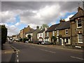
4
Houses at the junction of Widmore Road and Market Square
Image: © David Howard
Taken: 11 Mar 2012
0.06 miles
5
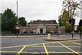
Bromley Crown Court
Lying by the inner ring road.
Image: © Bill Boaden
Taken: 10 Oct 2015
0.08 miles
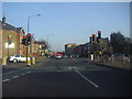
6
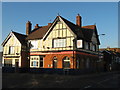
The Farwig Public House
On the junction of the A2212 College Road (on the right) and Farwig Lane (on the left).
Image: © David Anstiss
Taken: 27 Nov 2010
0.11 miles

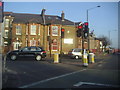
8
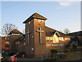
Bromley Methodist Church (2)
On the junction of North Street (on the right) and College Road (on the left).
Image: © David Anstiss
Taken: 27 Nov 2010
0.12 miles
9
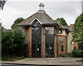
Bromley Methodist Church
Located on West Street.
Image: © Peter Trimming
Taken: 20 Aug 2015
0.13 miles