IMAGES TAKEN NEAR TO
Upper Park Road, BROMLEY, BR1 3PD
Introduction
This page details the photographs taken nearby to Upper Park Road, BR1 3PD by members of the Geograph project.
The Geograph project started in 2005 with the aim of publishing, organising and preserving representative images for every square kilometre of Great Britain, Ireland and the Isle of Man.

There are currently over 7.5m images from over14,400 individuals and you can help contribute to the project by visiting https://www.geograph.org.uk
Image Map
Images are licensed for reuse under creativecommons.org/licenses/by-sa/2.0
Notes
- Clicking on the map will re-center to the selected point.
- The higher the marker number, the further away the image location is from the centre of the postcode.
Image Listing (71 Images Found)
Images are licensed for reuse under creativecommons.org/licenses/by-sa/2.0
Image
Details
Distance
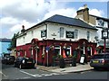
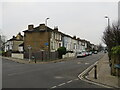
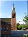
1
Upper Park Road, Bromley
The spire is that of the Trinity United Reformed Church (see Image).
Image: © Christopher Hilton
Taken: 30 Jul 2015
0.04 miles
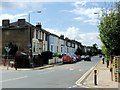
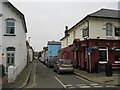
2
Freelands Grove, Bromley
Freelands Grove is a residential road in Bromley, in the outer suburbs of south east London.
This photo was taken on a dull and gloomy January afternoon. Trees were bare for the winter months.
Image: © Malc McDonald
Taken: 15 Jan 2022
0.04 miles
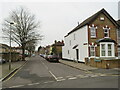
4
Park Road, Bromley
Park Road is a residential road in Bromley, in the outer suburbs of south east London.
This photo was taken on a dull and gloomy January afternoon.
Image: © Malc McDonald
Taken: 15 Jan 2022
0.05 miles
6
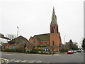
Trinity Bromley United Reformed Church
The United Reformed Church in Bromley, photographed on a dull and gloomy January afternoon. Some of the trees in the image were bare for the winter months, but there were also some evergreens which had kept their leaves.
Image: © Malc McDonald
Taken: 15 Jan 2022
0.05 miles
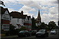
7
Trinity United Reformed Church, Bromley
Image: © Christopher Hilton
Taken: 30 Jul 2015
0.06 miles
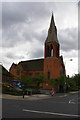
8
Trinity United Reformed Church
Built in 1895 as a Presbyterian Church, the spire of Trinity United Reformed Church is its most striking feature. It is seen here from Upper Park Road.
Image: © Marathon
Taken: 15 Jul 2011
0.06 miles
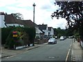
9
Plymouth Road, Bromley
Plymouth Road is a short and narrow residential cul-de-sac in Bromley, in the outer suburbs of south east London.
This photo was taken on a dull and gloomy January afternoon.
Image: © Malc McDonald
Taken: 15 Jan 2022
0.06 miles