IMAGES TAKEN NEAR TO
Babbacombe Road, BROMLEY, BR1 3LT
Introduction
This page details the photographs taken nearby to Babbacombe Road, BR1 3LT by members of the Geograph project.
The Geograph project started in 2005 with the aim of publishing, organising and preserving representative images for every square kilometre of Great Britain, Ireland and the Isle of Man.

There are currently over 7.5m images from over14,400 individuals and you can help contribute to the project by visiting https://www.geograph.org.uk
Image Map
Images are licensed for reuse under creativecommons.org/licenses/by-sa/2.0
Notes
- Clicking on the map will re-center to the selected point.
- The higher the marker number, the further away the image location is from the centre of the postcode.
Image Listing (117 Images Found)
Images are licensed for reuse under creativecommons.org/licenses/by-sa/2.0
Image
Details
Distance

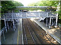
2
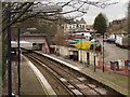
Sundridge Park Station
Sundridge Park Station on the spur line from Grove Park to Bromley North. This was originally designed in 1860 as a halt for the Scott family who lived close by at Sundrifge Park. It is only 640 yards from Bromley North Station.
Image: © sue hayton
Taken: 3 Mar 2002
0.05 miles
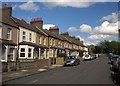
3
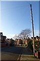
Along Rodway Road
A street of houses in North Bromley.
Image: © DS Pugh
Taken: 29 Nov 2014
0.06 miles

6
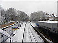
Sundridge Park station and the railway lines to its south
Sundridge Park station is on the short Bromley North Branch Line spur from Grove Park to Bromley North and is the only intermediate station on the branch.
Image: © Ashley Martin
Taken: 5 Feb 2012
0.07 miles
7
Sundridge Park station
The first service on the line between Grove Park and Bromley North stations ran on 1st January 1878. To appease the owner of Sundridge Park a station was opened between the two stations and called Plaistow. The buildings were added in the mid 1890s when housing development had virtually joined Plaistow to Bromley. The station was renamed Sundridge Park on 1st July 1894, partly as it sounded rather more upmarket and also to avoid confusion with the station of the same name in East London. It now operates as a shuttle service between Bromley North and Grove Park. This view is from the road bridge at Plaistow Lane towards Bromley North.
Image: © Marathon
Taken: 15 Jul 2011
0.07 miles
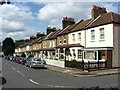
8
Plaistow Grove, Bromley
Part of a terrace of sixteen houses on the north side of the road which forms a crescent off Plaistow Lane.
Image: © Derek Harper
Taken: 9 May 2013
0.08 miles
9
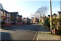
Rodway Road
A street in the northern parts of Bromley.
Image: © DS Pugh
Taken: 29 Nov 2014
0.08 miles
10
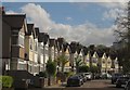
Babbacombe Road, Plaistow
Gables curve along the east side of the road. The further terrace is in Image
Image: © Derek Harper
Taken: 9 May 2013
0.09 miles