IMAGES TAKEN NEAR TO
Hawes Road, BROMLEY, BR1 3JR
Introduction
This page details the photographs taken nearby to Hawes Road, BR1 3JR by members of the Geograph project.
The Geograph project started in 2005 with the aim of publishing, organising and preserving representative images for every square kilometre of Great Britain, Ireland and the Isle of Man.

There are currently over 7.5m images from over14,400 individuals and you can help contribute to the project by visiting https://www.geograph.org.uk
Image Map
Images are licensed for reuse under creativecommons.org/licenses/by-sa/2.0
Notes
- Clicking on the map will re-center to the selected point.
- The higher the marker number, the further away the image location is from the centre of the postcode.
Image Listing (103 Images Found)
Images are licensed for reuse under creativecommons.org/licenses/by-sa/2.0
Image
Details
Distance
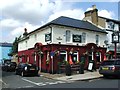
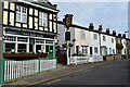
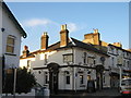
1
Red Lion Public House, Bromley
On North Road.
Image: © David Anstiss
Taken: 27 Nov 2010
0.06 miles
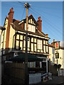
4
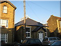
Freelands Hall
Former Church Hall converted into a private house on North Road.
Image: © David Anstiss
Taken: 27 Nov 2010
0.07 miles
5
The Red Lion pub and houses in North Road
Image: © David Martin
Taken: 8 Nov 2021
0.07 miles
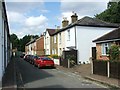
7
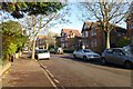
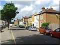
Along Rodway Road
A street of detached houses in North Bromley.
Image: © DS Pugh
Taken: 29 Nov 2014
0.07 miles
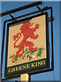
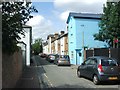
9
Freeland Tavern, Bromley
On the road junction of Freelands Road (on the right) and Plymouth Road (on the left).
Image: © David Anstiss
Taken: 27 Nov 2010
0.08 miles