IMAGES TAKEN NEAR TO
Hammelton Road, BROMLEY, BR1 3GJ
Introduction
This page details the photographs taken nearby to Hammelton Road, BR1 3GJ by members of the Geograph project.
The Geograph project started in 2005 with the aim of publishing, organising and preserving representative images for every square kilometre of Great Britain, Ireland and the Isle of Man.

There are currently over 7.5m images from over14,400 individuals and you can help contribute to the project by visiting https://www.geograph.org.uk
Image Map
Images are licensed for reuse under creativecommons.org/licenses/by-sa/2.0
Notes
- Clicking on the map will re-center to the selected point.
- The higher the marker number, the further away the image location is from the centre of the postcode.
Image Listing (80 Images Found)
Images are licensed for reuse under creativecommons.org/licenses/by-sa/2.0
Image
Details
Distance
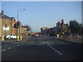
2
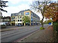
College Road, Bromley
The A2212 at the junction with Hammelton Road.
Image: © Derek Harper
Taken: 9 May 2013
0.08 miles
3
Lights on Market Square, Bromley
At the junction of Widmore Road
Image: © David Howard
Taken: 11 Mar 2012
0.09 miles
4
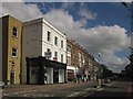
Shops on London Road, Bromley
This is the A21 London to Hastings road entering Bromley. The terrace of 12 shops is south of the junction with Hammelton Road.
Image: © Derek Harper
Taken: 9 May 2013
0.10 miles
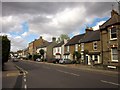
5

Approaching Bromley town centre
Where to park is an important consideration.
Image: © Bill Boaden
Taken: 10 Oct 2015
0.10 miles


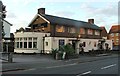
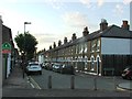
10
The Hop & Rye
Now closed and the site is awaiting redevelopment.
Image: © Oast House Archive
Taken: 5 Nov 2019
0.11 miles