IMAGES TAKEN NEAR TO
Andace Park Gardens, Widmore Road, BROMLEY, BR1 3DH
Introduction
This page details the photographs taken nearby to Andace Park Gardens, Widmore Road, BR1 3DH by members of the Geograph project.
The Geograph project started in 2005 with the aim of publishing, organising and preserving representative images for every square kilometre of Great Britain, Ireland and the Isle of Man.

There are currently over 7.5m images from over14,400 individuals and you can help contribute to the project by visiting https://www.geograph.org.uk
Image Map
Images are licensed for reuse under creativecommons.org/licenses/by-sa/2.0
Notes
- Clicking on the map will re-center to the selected point.
- The higher the marker number, the further away the image location is from the centre of the postcode.
Image Listing (36 Images Found)
Images are licensed for reuse under creativecommons.org/licenses/by-sa/2.0
Image
Details
Distance
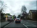
2
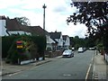
Tamasha Hotel
Large converted house, now restaurant and hotel on Widmore Road.
Image: © David Anstiss
Taken: 28 Aug 2011
0.08 miles
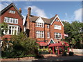
3
Bromley Cricket Club
Sports club house on Plaistow Lane.
Image: © David Anstiss
Taken: 28 Aug 2011
0.12 miles
6
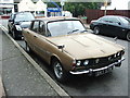
Vintage 1972 Rover P6, Beechfield Road, Bromley
Image: © Chris Whippet
Taken: 30 Aug 2015
0.20 miles
8
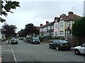
Cut through to Murray Avenue
Seen from Widmore Road, this attractive cut through provides a route to Bromley South station which avoids the busy Kentish Way.
Image: © Marathon
Taken: 15 Jul 2011
0.20 miles
9
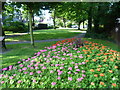
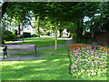
Flower bed by Widmore Road
Seen from Widmore Road, this attractive flower bed is next to a cut through. This provides a route to Murray Avenue and on to Bromley South station, avoiding the busy Kentish Way.
Image: © Marathon
Taken: 15 Jul 2011
0.21 miles
10
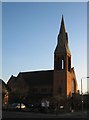
Trinity United Reformed Church, Bromley
On the junction of Upper Park Road (on the left) and Freelands Road (on the right).
Image: © David Anstiss
Taken: 27 Nov 2010
0.21 miles