IMAGES TAKEN NEAR TO
Edgeborough Way, BROMLEY, BR1 2UA
Introduction
This page details the photographs taken nearby to Edgeborough Way, BR1 2UA by members of the Geograph project.
The Geograph project started in 2005 with the aim of publishing, organising and preserving representative images for every square kilometre of Great Britain, Ireland and the Isle of Man.

There are currently over 7.5m images from over14,400 individuals and you can help contribute to the project by visiting https://www.geograph.org.uk
Image Map
Images are licensed for reuse under creativecommons.org/licenses/by-sa/2.0
Notes
- Clicking on the map will re-center to the selected point.
- The higher the marker number, the further away the image location is from the centre of the postcode.
Image Listing (25 Images Found)
Images are licensed for reuse under creativecommons.org/licenses/by-sa/2.0
Image
Details
Distance
1
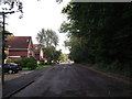
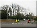
Romney Drive
This road is a cul-de-sac it leads towards Sundridge Avenue.
At the other end of the road is a footpath to Orchard Road.
Image: © David Anstiss
Taken: 18 Sep 2011
0.08 miles
2
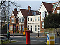
Breaside Preparatory School
On Orchard Road.
Image: © Robin Webster
Taken: 4 Feb 2012
0.08 miles
3
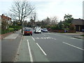
Romney Drive
With the morning post being delivered.
Image: © David Martin
Taken: 8 Nov 2021
0.09 miles
4
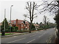
Orchard Road, Bromley
Orchard Road is a minor road in Bromley, in the outer suburbs of south east London. It forms part of the London Cycle Network.
This image was taken on a dull January afternoon. Deciduous trees were bare for winter, but the evergreens had kept their leaves.
Image: © Malc McDonald
Taken: 15 Jan 2022
0.09 miles
5
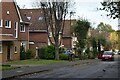
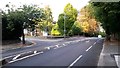
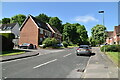
Sundridge Avenue, Bromley
Sundridge Avenue is a residential road in Bromley, in the outer suburbs of south east London.
This image was taken on a dull January afternoon. Deciduous trees were bare for winter, but the evergreens had kept their leaves.
Image: © Malc McDonald
Taken: 15 Jan 2022
0.09 miles
7
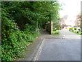
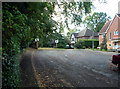
Pine Walk alongside Romney Drive
Pine Walk runs alongside Sundridge Park Golf Course and links Sundridge Avenue with Orchard Road in a straight line, instead of the longer route by road. It meets roads and houses at one or two points, like here where it follows Romney Drive before continuing ahead.
Image: © Marathon
Taken: 15 Jul 2011
0.10 miles
8
Looking towards the summit of Sundridge Avenue
Image: © David Martin
Taken: 26 Sep 2014
0.10 miles
10
Romney Drive BR1
This is a cul-de-sac. A footpath known (jokingly?) as Pine Walk continues westwards, to the left of the last house in Romney Drive. Sundridge Park golf course is behind the houses to the right.
Image: © Philip Talmage
Taken: 4 Nov 2005
0.11 miles