IMAGES TAKEN NEAR TO
Carlyle Avenue, BROMLEY, BR1 2RB
Introduction
This page details the photographs taken nearby to Carlyle Avenue, BR1 2RB by members of the Geograph project.
The Geograph project started in 2005 with the aim of publishing, organising and preserving representative images for every square kilometre of Great Britain, Ireland and the Isle of Man.

There are currently over 7.5m images from over14,400 individuals and you can help contribute to the project by visiting https://www.geograph.org.uk
Image Map
Images are licensed for reuse under creativecommons.org/licenses/by-sa/2.0
Notes
- Clicking on the map will re-center to the selected point.
- The higher the marker number, the further away the image location is from the centre of the postcode.
Image Listing (44 Images Found)
Images are licensed for reuse under creativecommons.org/licenses/by-sa/2.0
Image
Details
Distance
1
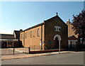
St Swithun's RC church BR2
In Fashoda Road.
Image: © Philip Talmage
Taken: 31 Aug 2005
0.10 miles
2
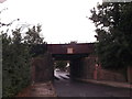
Railway bridge over The Avenue
The Avenue leads from Clarence Road to Page Heath Lane.
It leads under the railway between Bickley and Bromley South.
Image: © David Anstiss
Taken: 28 Aug 2011
0.11 miles
3
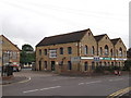
The Homesdale Centre, Bromley
Converted warehouses now offices on Homesdale Road.
Image: © David Anstiss
Taken: 28 Aug 2011
0.12 miles
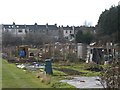
5
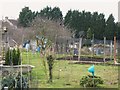
Allotments, Baths Road, BR2 (2)
The east branch of the River Ravensbourne runs through the allotments - see the satellite image http://wtp2.appspot.com/wheresthepath.htm?lat=51.39653816893914&lon=0.03735244274139404&gz=18&oz=10>=1.
Image: © Mike Quinn
Taken: 12 Mar 2010
0.12 miles
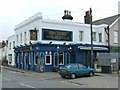
6
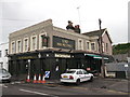
Lord Homesdale Public House, Bromley
On Holmesdale Road.
Image: © David Anstiss
Taken: 28 Aug 2011
0.12 miles
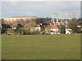
9
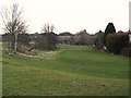
The northern part of Havelock Recreation Ground
Image: © Mike Quinn
Taken: 12 Mar 2010
0.13 miles
10
Allotments, Baths Road, BR2 (3)
The east branch of the River Ravensbourne runs left to right at the far side of the allotments - see the satellite image http://wtp2.appspot.com/wheresthepath.htm?lat=51.39653816893914&lon=0.03735244274139404&gz=18&oz=10>=1.
Image: © Mike Quinn
Taken: 12 Mar 2010
0.13 miles