IMAGES TAKEN NEAR TO
Homesdale Road, BROMLEY, BR1 2RA
Introduction
This page details the photographs taken nearby to Homesdale Road, BR1 2RA by members of the Geograph project.
The Geograph project started in 2005 with the aim of publishing, organising and preserving representative images for every square kilometre of Great Britain, Ireland and the Isle of Man.

There are currently over 7.5m images from over14,400 individuals and you can help contribute to the project by visiting https://www.geograph.org.uk
Image Map
Images are licensed for reuse under creativecommons.org/licenses/by-sa/2.0
Notes
- Clicking on the map will re-center to the selected point.
- The higher the marker number, the further away the image location is from the centre of the postcode.
Image Listing (36 Images Found)
Images are licensed for reuse under creativecommons.org/licenses/by-sa/2.0
Image
Details
Distance
4
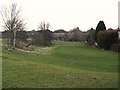
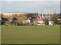
The northern part of Havelock Recreation Ground
Image: © Mike Quinn
Taken: 12 Mar 2010
0.05 miles
5
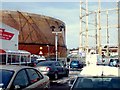
Bromley Tesco View
The view of the Gasometers from the Tesco car park.
Image: © Gordon Griffiths
Taken: 5 Feb 2009
0.07 miles


9
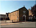
St Swithun's RC church BR2
In Fashoda Road.
Image: © Philip Talmage
Taken: 31 Aug 2005
0.08 miles