IMAGES TAKEN NEAR TO
Copley Dene, BROMLEY, BR1 2PW
Introduction
This page details the photographs taken nearby to Copley Dene, BR1 2PW by members of the Geograph project.
The Geograph project started in 2005 with the aim of publishing, organising and preserving representative images for every square kilometre of Great Britain, Ireland and the Isle of Man.

There are currently over 7.5m images from over14,400 individuals and you can help contribute to the project by visiting https://www.geograph.org.uk
Image Map
Images are licensed for reuse under creativecommons.org/licenses/by-sa/2.0
Notes
- Clicking on the map will re-center to the selected point.
- The higher the marker number, the further away the image location is from the centre of the postcode.
Image Listing (20 Images Found)
Images are licensed for reuse under creativecommons.org/licenses/by-sa/2.0
Image
Details
Distance
1
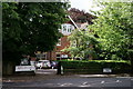
Bickley
Ripley Arts Centre, on Sundridge Avenue.
Image: © Peter Trimming
Taken: 18 Jul 2017
0.08 miles
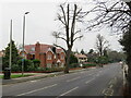
2
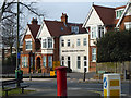
Sundridge Avenue, Bromley
Sundridge Avenue is a residential road in Bromley, in the outer suburbs of south east London.
This image was taken on a dull January afternoon. Deciduous trees were bare for winter, but the evergreens had kept their leaves.
Image: © Malc McDonald
Taken: 15 Jan 2022
0.08 miles
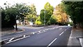
3
Orchard Road, Bromley
Orchard Road is a minor road in Bromley, in the outer suburbs of south east London. It forms part of the London Cycle Network.
This image was taken on a dull January afternoon. Deciduous trees were bare for winter, but the evergreens had kept their leaves.
Image: © Malc McDonald
Taken: 15 Jan 2022
0.09 miles
4
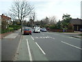
Looking towards the summit of Sundridge Avenue
Image: © David Martin
Taken: 26 Sep 2014
0.11 miles
6
Breaside Preparatory School
On Orchard Road.
Image: © Robin Webster
Taken: 4 Feb 2012
0.11 miles
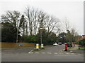
7
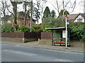
Hill Brow bus stop on Sundridge Avenue
Served by route 314 towards New Eltham.
Image: © Robin Webster
Taken: 4 Feb 2012
0.12 miles
8
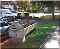
Widmore Green Drinking Trough
Beside a small car park beside Plaistow Lane.
It is a Grade II listed Granite cattle trough of the Metropolitan Drinking and Cattle Trough Association, erected 1904. This cattle trough, with human drinking fountain at one end and dog trough beneath.
See http://www.britishlistedbuildings.co.uk/en-494742-water-trough-at-widmore-green-bromley for more details on the trough.
Image: © David Anstiss
Taken: 28 Aug 2011
0.18 miles
9
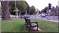
Roadside bench
For a fine view of the evening rush hour.
Image: © David Martin
Taken: 26 Sep 2014
0.18 miles
10
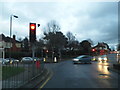
Widmore Road at the junction of Plaistow Lane
Image: © David Howard
Taken: 24 Dec 2012
0.19 miles