1
Clarence Road, Bickley after rain
A number of roads in Beckenham and Bromley are not made up. Clarence Road in Bickley is one of them. This view is looking back from the railway bridge.
Image: © Marathon
Taken: 24 Aug 2011
0.07 miles
2
Railway near Bickley
View from Bickley towards Bromley South.
Image: © Wayland Smith
Taken: 5 May 2018
0.08 miles
3
A rather large puddle in Clarence Road, Bickley
A number of roads in Beckenham and Bromley are not made up. Clarence Road in Bickley, to the north of The Avenue, is one of them. This view is looking beyond a large puddle, the result of rain that morning, and across The Avenue to houses in the surfaced part of Clarence Road.
Image: © Marathon
Taken: 24 Aug 2011
0.08 miles
4
Clarence Road, Bickley
A number of roads in Beckenham and Bromley are not made up. Clarence Road in Bickley is one of them. This view is looking across the railway bridge. Unfortunately the parapet is too high to see over.
Image: © Marathon
Taken: 24 Aug 2011
0.09 miles
5
Allotment on Baths Road
Large block of allotments that surround
Image (on the right).
Image: © David Anstiss
Taken: 28 Aug 2011
0.10 miles
6
Railway bridge over The Avenue
The Avenue leads from Clarence Road to Page Heath Lane.
It leads under the railway between Bickley and Bromley South.
Image: © David Anstiss
Taken: 28 Aug 2011
0.11 miles
7
Virgin Active Health Club, Bromley
On Baths Road.
Used to be a former council baths.
Image: © David Anstiss
Taken: 28 Aug 2011
0.13 miles
8
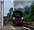
No.34067 'Tangmere' at Bickley Station
Battle of Britain class No.34067 'Tangmere'; seen hauling 'The Cathedrals Express' through Bickley. This was a circular tour, from Victoria, via Maidstone East, Hastings, Tunbridge Wells and Tonbridge.
Image: © Peter Trimming
Taken: 21 Jun 2011
0.14 miles
9
Allotments, Baths Road, BR2 (2)
The east branch of the River Ravensbourne runs through the allotments - see the satellite image http://wtp2.appspot.com/wheresthepath.htm?lat=51.39653816893914&lon=0.03735244274139404&gz=18&oz=10>=1.
Image: © Mike Quinn
Taken: 12 Mar 2010
0.14 miles
10
Allotments, Baths Road, BR2 (3)
The east branch of the River Ravensbourne runs left to right at the far side of the allotments - see the satellite image http://wtp2.appspot.com/wheresthepath.htm?lat=51.39653816893914&lon=0.03735244274139404&gz=18&oz=10>=1.
Image: © Mike Quinn
Taken: 12 Mar 2010
0.16 miles


