IMAGES TAKEN NEAR TO
Ringers Road, BROMLEY, BR1 1HX
Introduction
This page details the photographs taken nearby to Ringers Road, BR1 1HX by members of the Geograph project.
The Geograph project started in 2005 with the aim of publishing, organising and preserving representative images for every square kilometre of Great Britain, Ireland and the Isle of Man.

There are currently over 7.5m images from over14,400 individuals and you can help contribute to the project by visiting https://www.geograph.org.uk
Image Map
Images are licensed for reuse under creativecommons.org/licenses/by-sa/2.0
Notes
- Clicking on the map will re-center to the selected point.
- The higher the marker number, the further away the image location is from the centre of the postcode.
Image Listing (164 Images Found)
Images are licensed for reuse under creativecommons.org/licenses/by-sa/2.0
Image
Details
Distance
4
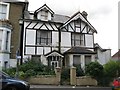
Victorian house in Ethelbert Road, BR1
See Image Photo taken with the kind permission of the house owner.
Image: © Mike Quinn
Taken: 4 Sep 2009
0.05 miles
6
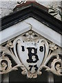
Date stone on the Victorian house in Ethelbert Road, BR1
See Image Photo taken with the kind permission of the house owner.
Image: © Mike Quinn
Taken: 4 Sep 2009
0.06 miles
9
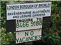
Sign for the Ravensbourne Allotments
Image: © Mike Quinn
Taken: 4 Sep 2009
0.06 miles