IMAGES TAKEN NEAR TO
Ringmer Road, NEWHAVEN, BN9 9TN
Introduction
This page details the photographs taken nearby to Ringmer Road, BN9 9TN by members of the Geograph project.
The Geograph project started in 2005 with the aim of publishing, organising and preserving representative images for every square kilometre of Great Britain, Ireland and the Isle of Man.

There are currently over 7.5m images from over14,400 individuals and you can help contribute to the project by visiting https://www.geograph.org.uk
Image Map
Images are licensed for reuse under creativecommons.org/licenses/by-sa/2.0
Notes
- Clicking on the map will re-center to the selected point.
- The higher the marker number, the further away the image location is from the centre of the postcode.
Image Listing (21 Images Found)
Images are licensed for reuse under creativecommons.org/licenses/by-sa/2.0
Image
Details
Distance
1

Ringmer Road, Harbour Heights
Laid out in the 1920s as part of Harbour Heights which the war and tougher planning laws bought to a halt. There are currently three dwellings along this dead end unmade road.
Image: © Simon Carey
Taken: 31 Aug 2012
0.03 miles
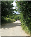
2
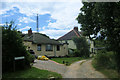
Ringmer Road, Newhaven
Taken from the junction of Upper Valley Road. Both roads are unmade. Note the telecommunication tower and the old anchor in the garden of the bungalow on the left.
Image: © Kevin Gordon
Taken: 20 Jul 2008
0.05 miles
3

The Highway, Harbour Heights
Now a restricted byway and part of national cycle route 2 but until the 1820s this was the main road from Newhaven to Brighton and was replaced by a turnpike with a lesser gradient that made it easier for coaches. Still used by vehicles to access the scattered houses on Harbour Heights and Peacehaven Heights.
Image: © Simon Carey
Taken: 31 Aug 2012
0.07 miles
4

Newhaven Transmitter Mast
A BBC digital television and radio relay mast for Heathfield to the north.
Image: © Simon Carey
Taken: 31 Aug 2012
0.08 miles
5

Wilmington Road, Harbour Heights
Laid out in the 1920s and originally linked up to Pevensey Road but since the construction of a small estate to the west of Tideway school it is now a dead end.
Image: © Simon Carey
Taken: 31 Aug 2012
0.08 miles
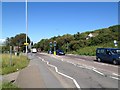
6
View from Upper Valley Road
This looks across Brighton Road (A259).
Image: © Marathon
Taken: 5 Jun 2021
0.10 miles
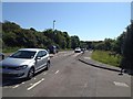
9
Upper Valley Road, Newhaven
Looking north from the junction of Ringmer Road. The red bus in the centre of the view shows the location of the A259 with the golf course seen in the distance.
Image: © Kevin Gordon
Taken: 20 Jul 2008
0.11 miles
10

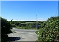
Three Entrances, Brighton Road
In the foreground is the junction of Upper Valley Road an unmade road that heads south to link up with The Highway and originated as a farm track accessing Hill Barn. On the opposite to the right is Valley Road which descends into the dry valley and also originates as a farm track leading to a sheepfold and was given its current name during the 1920s when plots of land were sold and began to be built upon. It is now a dead end and only a fool would attempt to do the national speed limit down it. This unmade road was replaced in the 1990s by the new modern road on the left, The Fairway which is the only access for a residential estate just visible below. Peacehaven Golf Course is to the left on the hill.
Image: © Simon Carey
Taken: 31 Aug 2012
0.11 miles