IMAGES TAKEN NEAR TO
Lewes Road, NEWHAVEN, BN9 9RT
Introduction
This page details the photographs taken nearby to Lewes Road, BN9 9RT by members of the Geograph project.
The Geograph project started in 2005 with the aim of publishing, organising and preserving representative images for every square kilometre of Great Britain, Ireland and the Isle of Man.

There are currently over 7.5m images from over14,400 individuals and you can help contribute to the project by visiting https://www.geograph.org.uk
Image Map
Images are licensed for reuse under creativecommons.org/licenses/by-sa/2.0
Notes
- Clicking on the map will re-center to the selected point.
- The higher the marker number, the further away the image location is from the centre of the postcode.
Image Listing (168 Images Found)
Images are licensed for reuse under creativecommons.org/licenses/by-sa/2.0
Image
Details
Distance

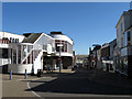
2
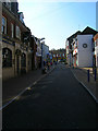
High Street
Once the A259 until the northern and southern ring roads were built in the late 1970s and the main shopping street became pedestrianised. However, over the years the major shops have moved out and the High Street became run down with many boarded up shops. Traffic was allowed back into the High Street a few years ago but even at midday the place looks very underpopulated. Unlike Dieppe where there are a number of things to keep you in the town on a day trip, for those coming from France, Newhaven is place to get off the ferry and onto a train to head to Lewes or Brighton and therein lies the problem the town has.
Image: © Simon Carey
Taken: 23 Oct 2007
0.07 miles
3
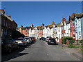
Harpers Road
Built in the first decade of the 20th century and named after the field, Harpers Croft, it was built in. The road runs between Lewes Road and Brighton Road and is one way to prevent it being used as a rat run.
Image: © Simon Carey
Taken: 31 Aug 2012
0.08 miles
4
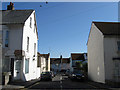
Ship Street
A short street lying between Lewes Road and Elphick Road with just one dwelling on it. Built in the late 19th century along with a large proportion of the other terraced housing in the vicinity.
Image: © Simon Carey
Taken: 31 Aug 2012
0.08 miles
5
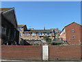
Site of Newhaven Conservative Club
Located at the junction of South Way and Brighton Road and built in the first decade of the 20th century it burnt down in July 2010. The remains of the building have been removed and the site is currently empty awaiting development. Plenty of rumours have been flying around about planning applications before and after though the fire though fire brigade have insisted it was not started deliberately.
Image: © Simon Carey
Taken: 31 Aug 2012
0.08 miles
6
High Street
The street from which the town of Newhaven grew up around viewed from the junction with Meeching Road. Until the late 1970s this was the A259, then a couple of ring roads took the traffic away but in the process formed a shopping area which nobody saw. The road was pedestrianised in 1981 and over the years the businesses pulled out as footfall dropped. Traffic was reintroduced at the beginning of this century between Bridge Street and Meeching Road but the street is still dying not helped by a proliferation of new large supermarkets on the eastern side of the river. The steps on the left currently lead to a church though the space above has been used as a gym and night club in the past.
Image: © Simon Carey
Taken: 26 Aug 2012
0.08 miles
7
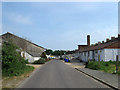
Robinson Road
The road once headed south to Essex Place then via narrow streets made its way to the High Street. However, the construction of the town's ring road in the early 1980s resulted in the demolition of Essex Place and turning Robinson Road into a dead end. The road provides access to the boatyards along the old cut of the river along with a few works and a council depot at the far end of the street.
Image: © Simon Carey
Taken: 2 Jun 2012
0.08 miles
9
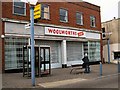
Woolworths local at Newhaven
The sign is still there indicating the site has not been sold over a year after the firm closed
Image: © Paul Gillett
Taken: 17 Mar 2010
0.09 miles
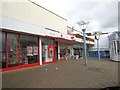
10

Market Stall, Newhaven High Street
The market was opened in October 2013, funded with money secured from the Mary Portas scheme to revive flagging high streets. http://www.sussexexpress.co.uk/news/local/new-market-pulls-in-the-crowds-to-newhaven-high-street-1-5378858
Image: © Paul Gillett
Taken: 9 Jan 2014
0.09 miles