
IMAGES TAKEN NEAR TO
Bridge Street, NEWHAVEN, BN9 9PJ
Introduction
This page details the photographs taken nearby to Bridge Street, BN9 9PJ by members of the Geograph project.
The Geograph project started in 2005 with the aim of publishing, organising and preserving representative images for every square kilometre of Great Britain, Ireland and the Isle of Man.

There are currently over 7.5m images from over14,400 individuals and you can help contribute to the project by visiting https://www.geograph.org.uk
Image Map
Images are licensed for reuse under creativecommons.org/licenses/by-sa/2.0
Notes
- Clicking on the map will re-center to the selected point.
- The higher the marker number, the further away the image location is from the centre of the postcode.
Image Listing (197 Images Found)
Images are licensed for reuse under creativecommons.org/licenses/by-sa/2.0
Image
Details
Distance
1
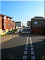
Bridge Street
Once the A259 until the southern and northern ring roads were built. Remained open to traffic unlike High Street though only as a service road for the local shops. Taken from the junction of Chapel Street.
Image: © Simon Carey
Taken: 23 Oct 2007
0.02 miles
2
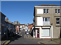
Bridge Street
Running between South Way and High Street it was laid out in the 1860s as part of the enterprise by the LBSCR to build Newhaven into a working port. The street was built as part of the plan to provide a new crossing over the River Ouse to replace the old bridge whose land opposite was being turned into an island by a straightening of the river. For many years this was the A259 until traffic congestion induced the local council to build a series of ring roads and new bridge crossing that opened in 1974. Since then street has become an access road for the remaining local shops and Denton Island if approaching from the east.
Image: © Simon Carey
Taken: 26 Aug 2012
0.03 miles
3
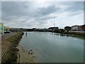
River Ouse on west side of Denton Island
Looking towards Newhaven Swing Bridge. The current bridge opened in 1974 replacing an older bridge slightly to the south. It carries the A259 over the River Ouse.
Image: © Gerald England
Taken: 27 Apr 2017
0.03 miles
4
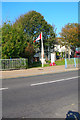
Canadian War Memorial
Taken from South Way looking towards a small green at the junction of that road and Bridge Street. The memorial is dedicated to the many Canadians who set out from Newhaven in 1942 for the ill-fated raid on Dieppe from which few returned.
Image: © Simon Carey
Taken: 23 Oct 2007
0.04 miles
5
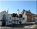
The Bridge
Built as a cottage in the 17th it later became the New Inn changing its name to the Bridge Inn in 1784 when the new bridge over the river was opened. The owner had been one of the sponsors and the meeting to apply for the act of parliament required for the crossing had been held here. Over the years it has been either the Bridge inn, Bridge Hotel or just plain Bridge, as it is now. Its former brewery was located in Bridge Street which later became a Drill Hall which was removed when North Way ring road was constructed in the early 1970s. The inn's most famous visitor was a certain Mr Smith who lodged here one night in 1848 having disembarked from a ferry from Dieppe. Mr Smith was Louis Phillipe, the deposed King of France spending his first night in exile.
Image: © Simon Carey
Taken: 26 Aug 2012
0.04 miles
6
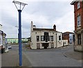
The Bridge Hotel
On the corner of Bridge Street and High Street is the Grade II listed https://historicengland.org.uk/listing/the-list/list-entry/1280332 Bridge Hotel Image It dates originally to the 17th century. The pub's main claim to fame was the overnight stay in 1848, of King Louis Philippe of France and his Queen Marie Amelie during their flight from the French Revolution. It is currently closed.
Image: © Gerald England
Taken: 27 Apr 2017
0.04 miles
7
Sign of The Bridge
Sign for The Bridge Image
Image: © Gerald England
Taken: 27 Apr 2017
0.04 miles
9
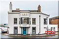
Bridge Inn
18th Century pub in Bridge Street, opposite the end of High Street. Grade II listed - see https://historicengland.org.uk/listing/the-list/list-entry/1280332?section=official-list-entry. On both sides of the bay is the inscription "Hosted the last King of France 1848", in reference to King Louis Philippe and his family spending their first night in England here, having fled from France during the 1848 Revolution.
Image: © Ian Capper
Taken: 21 May 2024
0.04 miles
10
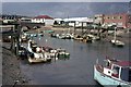
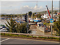
Small Craft on the River Ouse
With Denton Island on the right. Taken on Bank Holiday Monday.
Image: © Peter Jeffery
Taken: Unknown
0.04 miles