IMAGES TAKEN NEAR TO
Newhaven Heights, NEWHAVEN, BN9 9HD
Introduction
This page details the photographs taken nearby to Newhaven Heights, BN9 9HD by members of the Geograph project.
The Geograph project started in 2005 with the aim of publishing, organising and preserving representative images for every square kilometre of Great Britain, Ireland and the Isle of Man.

There are currently over 7.5m images from over14,400 individuals and you can help contribute to the project by visiting https://www.geograph.org.uk
Image Map
Images are licensed for reuse under creativecommons.org/licenses/by-sa/2.0
Notes
- Clicking on the map will re-center to the selected point.
- The higher the marker number, the further away the image location is from the centre of the postcode.
Image Listing (42 Images Found)
Images are licensed for reuse under creativecommons.org/licenses/by-sa/2.0
Image
Details
Distance
1
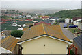
Choosy lichen at Newhaven Heights
Living on this "private park" of mini-houses is a curiously choosy orange-yellow lichen. On the near roof it is profuse, and on a few others, yet most roofs are completely clean. With one exception, the only roofs with lichen are those that started out light grey. It is the more intense colours that are clean. The exception, just inside the boundary straight ahead, is light red.
Image: © Robin Webster
Taken: 15 Jul 2010
0.03 miles
2
Hello Up There!
A couple of people pose for a dramatic picture at the top of Burrow Head. Viewed from West Beach below.
Image: © Simon Carey
Taken: 29 May 2008
0.07 miles
3
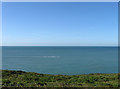
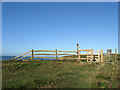
Looking out to Sea
View from the cliff top footpath at the western end of Castle Hill Nature Reserve. The boat would come to a halt a little to the west of Old Nore Point.
Image: © Simon Carey
Taken: 31 Aug 2012
0.07 miles
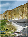
4
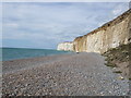
Burrow Head
Viewed from the rocks at low tide. The shingle to the right protects the bases of the cliffs whereas those to the left are showing visible signs of erosion.
Image: © Simon Carey
Taken: 29 May 2008
0.08 miles
5
Entrance, Castle Hill Nature Reserve
Also a footpath junction. Straight ahead along the cliff top will get you to Peacehaven, turn right and descend through Newhaven heights caravan park to Court Farm Road to take you back to Newhaven. Turn left and it's a long drop down to the beach.
Image: © Simon Carey
Taken: 31 Aug 2012
0.09 miles
6
Beach near Burrow Head
West of Newhaven Harbour
Image: © Paul Gillett
Taken: 29 Aug 2011
0.10 miles
7
West Beach Newhaven
The extreme end of west beach Newhaven
Looking west
Image: © Mike Bovington
Taken: 22 Jan 2005
0.10 miles
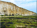
8
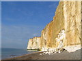
Rocks and Shingle
At the base of the cliffs at low tide, the green on the cliff denoting the height of the water at high tide. Also visible in the cliff base are bits of flint. The ferry in the distance has just reversed out of Newhaven harbour and is about to turn round and head off to France.
Image: © Simon Carey
Taken: 29 May 2008
0.12 miles
9
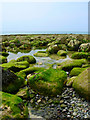
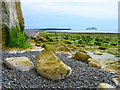
Rock Pool
Underneath the cliffs to the west of Newhaven at low tide. A small area between the shingle and eroded cliff bases are filled with large rocks which I assume will be eventually weathered down and moved along the beach.
Image: © Simon Carey
Taken: 29 May 2008
0.12 miles
10
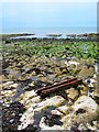
Eroded Cliffs, West Beach
The metal comes from Image whilst there is a lone post further out. Taken at low tide.
Image: © Simon Carey
Taken: 29 May 2008
0.12 miles