IMAGES TAKEN NEAR TO
West Pier, NEWHAVEN, BN9 9DN
Introduction
This page details the photographs taken nearby to West Pier, BN9 9DN by members of the Geograph project.
The Geograph project started in 2005 with the aim of publishing, organising and preserving representative images for every square kilometre of Great Britain, Ireland and the Isle of Man.

There are currently over 7.5m images from over14,400 individuals and you can help contribute to the project by visiting https://www.geograph.org.uk
Image Map (Loading...)


Getting Data...Please wait
Leaflet Map data © OpenStreetMap
Images are licensed for reuse under creativecommons.org/licenses/by-sa/2.0
Notes
- Clicking on the map will re-center to the selected point.
- The higher the marker number, the further away the image location is from the centre of the postcode.
Image Listing (177 Images Found)
Images are licensed for reuse under creativecommons.org/licenses/by-sa/2.0
Image
Details
Distance
1
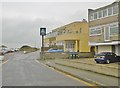
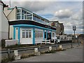
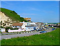
Newhaven, Hope Inn
Good Beer Guide-listed public house on West Pier. Internally, despite modernisation, lots of interest; back counter, eating and drinking areas front and right, darts and open fire, with an old pub sign, tackle, and oars on the ceiling; upstairs terrace. Cask ales on offer: 61 Pale Ale, Harvey's Bitter, Robin Hood Pale.
Image: © Mike Faherty
Taken: 24 Nov 2018
0.00 miles
3
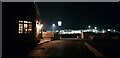
Fort Road at Night
The Hope Inn is on the left.
Image: © Paul Collins
Taken: 15 Nov 2021
0.01 miles
4
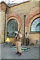
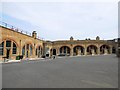
Tommy -Newhaven Fort
Re-enactment During the Living History weekend July 2013
Image: © Paul Gillett
Taken: 27 Jul 2013
0.01 miles
5
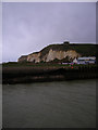
The Hope Inn
Just inside the square on the western side of the river. Taken from the East Pier with the wind making it difficult to hold the camera still. Beyond are the cliffs of Castle Hill.
Image: © Simon Carey
Taken: 8 Mar 2008
0.01 miles
6
The Hope Inn, Newhaven
On the Fort Road near West Pier
Image: © Paul Gillett
Taken: 29 Aug 2011
0.01 miles
8
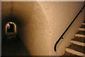
Newhaven fort, caponier tunnel
This is one of those secret passageways beloved of young boys. It leads to the caponier, a forward gun emplacement concealed in the cliff outside the wall of the fort. I was the only one around and I admit it was quite spooky.
Image: © Graham Horn
Taken: 27 Jun 2010
0.02 miles
9
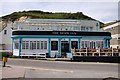
Hope Inn, Fort Road
The public house is a rebuild from an earlier one and judging by the art decoish exterior and chimneys may well originate from the 1930s. The house to the left is Seahouse and was part of the original buildings and is the only part remaining. Up to the mid 1960s the view would also have included a single track railway which ran from Newhaven station over the swing bridge then down the West Quay to the breakwater and beyond in order to collect shingle for use as ballast. See http://www.francisfrith.com/search/england/east+sussex/newhaven/photos/newhaven_N20077.htm for a similar view from 1965.
Image: © Simon Carey
Taken: 29 May 2008
0.02 miles
10
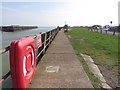
Path by Newhaven Harbour/River Ouse
Image: © Richard Rogerson
Taken: 24 Mar 2017
0.03 miles