IMAGES TAKEN NEAR TO
West Quay, NEWHAVEN, BN9 9BT
Introduction
This page details the photographs taken nearby to West Quay, BN9 9BT by members of the Geograph project.
The Geograph project started in 2005 with the aim of publishing, organising and preserving representative images for every square kilometre of Great Britain, Ireland and the Isle of Man.

There are currently over 7.5m images from over14,400 individuals and you can help contribute to the project by visiting https://www.geograph.org.uk
Image Map (Loading...)


Getting Data...Please wait
Leaflet Map data © OpenStreetMap
Images are licensed for reuse under creativecommons.org/licenses/by-sa/2.0
Notes
- Clicking on the map will re-center to the selected point.
- The higher the marker number, the further away the image location is from the centre of the postcode.
Image Listing (146 Images Found)
Images are licensed for reuse under creativecommons.org/licenses/by-sa/2.0
Image
Details
Distance
1
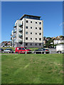
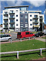
Versailles, West Quay
Part of the recent completed flats that lie at the southern end of West Quay. There are four blocks in total all named after ferries that once plied their trade between Newhaven and Dieppe. See also Image and Image
Image: © Simon Carey
Taken: 26 Aug 2012
0.03 miles
2
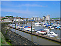
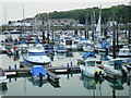
Sleeper's Hole
Looking around the edge of the small marina with the new development on Western Quay at the northern edge. The Western Quay used to be the location for the town's coal wharves.
Image: © Simon Carey
Taken: 29 May 2008
0.04 miles
3
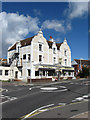
The Harbourside
Public house on the corner of Fort Road and Gibbon Road. Built in 1891 and for many years was the Sheffield Arms Hotel.
Image: © Simon Carey
Taken: 26 Aug 2012
0.05 miles
4
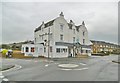
Newhaven, Co-op
A prominent building on Fort Road, dating from 1891; apartments above.
Image: © Mike Faherty
Taken: 24 Nov 2018
0.05 miles
5
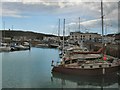
Newhaven marina
Calm day at marina, fort in background.
Image: © cynthia hudson
Taken: 29 Jul 2011
0.05 miles
6
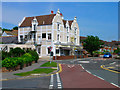
The Harbourside, Fort Road
Former hotel constructed in 1891 on the junction of Fort Road and Gibbon Road. Previously known as the Sheffield Arms and named after the local landowner, the hotel/pub only changed its name four years ago. There has been mention of a previous pub bearing the same name on or near the site from the 1860s serving a small shanty town that grew up whlst the nearby breakwater was being constructed. The area between the two road junctions on the left (Court Farm Road and Gibbon Road) was once a tramway connecting the nearby Meeching Quarry to the harbourside and operated between 1878 and 1939.
Image: © Simon Carey
Taken: 29 May 2008
0.05 miles
7
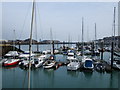
Newhaven Marina
Situated a quarter of a mile in from the harbour entrance on the western bank of the River Ouse, Newhaven Marina offers good shelter at all times and is accessible in all weathers and all tides. The Marina has moorings for up to 300 craft from 7.5 metre to 15.5 metre http://www.newhavenmarina.co.uk/information.html
Image: © Paul Gillett
Taken: 29 Aug 2011
0.05 miles
8
Valencay, West Quay
Part of the recent completed flats that lie at the southern end of West Quay. There are four blocks in total all named after ferries that once plied their trade between Newhaven and Dieppe. See also Image and Image
Image: © Simon Carey
Taken: 26 Aug 2012
0.05 miles
9
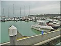
Newhaven Marina
The Marina has moorings for up to 300 craft from 7.5 metre to 15.5 metre on pontoons between individual finger piers http://www.newhavenmarina.co.uk/
Image: © Paul Gillett
Taken: 17 Mar 2010
0.05 miles
10
Newhaven Marina
Off Fort Road: http://www.newhavenmarina.co.uk/information/marina_facilities.html
Image: © Mike Faherty
Taken: 24 Nov 2018
0.06 miles