IMAGES TAKEN NEAR TO
Denton Island, NEWHAVEN, BN9 9BA
Introduction
This page details the photographs taken nearby to Denton Island, BN9 9BA by members of the Geograph project.
The Geograph project started in 2005 with the aim of publishing, organising and preserving representative images for every square kilometre of Great Britain, Ireland and the Isle of Man.

There are currently over 7.5m images from over14,400 individuals and you can help contribute to the project by visiting https://www.geograph.org.uk
Image Map
Images are licensed for reuse under creativecommons.org/licenses/by-sa/2.0
Notes
- Clicking on the map will re-center to the selected point.
- The higher the marker number, the further away the image location is from the centre of the postcode.
Image Listing (148 Images Found)
Images are licensed for reuse under creativecommons.org/licenses/by-sa/2.0
Image
Details
Distance
1
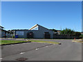
Denton Island Community centre
Image: © Simon Carey
Taken: 26 Aug 2012
0.02 miles
2
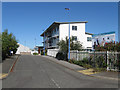
Newhaven Enterprise centre
Completed in 2007 on the site of an old electrical engineering firm.
Image: © Simon Carey
Taken: 26 Aug 2012
0.02 miles
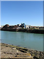
3
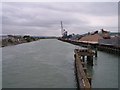
North Quay, Newhaven
Looking up the River Ouse from the swing bridge.
Image: © Bob Embleton
Taken: 1 Jun 2006
0.04 miles
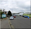
4

Expanded Polystyrene Supplies
Small business supplying plastic and foam products on the island. The road looks towards the bridge and the High Street.
Image: © Simon Carey
Taken: 26 Aug 2012
0.05 miles
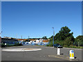
5
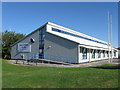
Sussex Downs College
The Newhaven campus of the tertiary college that was an amalgamation of a number of colleges across East Sussex.
Image: © Simon Carey
Taken: 26 Aug 2012
0.06 miles
6
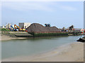
North Quay
Viewed from a disused slipway on Denton Island. The quay is on the part of the river that was straightened in the 1860s and created Denton Island in the process, it is one of two of the original four quays of the harbour still in use, its mainstays being scrap metal and aggregates.
Image: © Simon Carey
Taken: 26 Aug 2012
0.06 miles
7
Entrance, Peter Leonard Marine
The boatyard has been on the island since 1992.
Image: © Simon Carey
Taken: 26 Aug 2012
0.07 miles
8
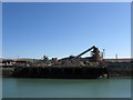
North Quay
The quay is on the part of the river that was straightened in the 1860s and created Denton Island in the process, it is one of two of the original four quays of the harbour still in use, its mainstays being scrap metal and aggregates.
Image: © Simon Carey
Taken: 26 Aug 2012
0.07 miles
9
Denton Island
Industrial units on Denton Island.
Image: © Gerald England
Taken: 27 Apr 2017
0.08 miles
10
North Quay
Viewed from the western side of the river where the new cut and old course of the river join at what is known as the Swinging Basin. The northern end is used by a scrap metal merchant Jordan & Hughes.
Image: © Simon Carey
Taken: 2 Jun 2012
0.08 miles