IMAGES TAKEN NEAR TO
Bush Road, NEWHAVEN, BN9 9AB
Introduction
This page details the photographs taken nearby to Bush Road, BN9 9AB by members of the Geograph project.
The Geograph project started in 2005 with the aim of publishing, organising and preserving representative images for every square kilometre of Great Britain, Ireland and the Isle of Man.

There are currently over 7.5m images from over14,400 individuals and you can help contribute to the project by visiting https://www.geograph.org.uk
Image Map
Images are licensed for reuse under creativecommons.org/licenses/by-sa/2.0
Notes
- Clicking on the map will re-center to the selected point.
- The higher the marker number, the further away the image location is from the centre of the postcode.
Image Listing (27 Images Found)
Images are licensed for reuse under creativecommons.org/licenses/by-sa/2.0
Image
Details
Distance
1
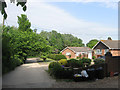
Bush Road
Small cul-de-sac off Lewes Road built in the early 1980s. The road is private but is the start of the public footpath leads to Peacehaven.
Image: © Simon Carey
Taken: 2 Jun 2012
0.02 miles
2
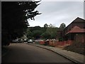
Piddinghoe Mead
Small cul de sac at the northern end of Newhaven built on the site and utilising some of the old buildings of Newhaven Isolation Hospital.
Image: © Simon Carey
Taken: 16 Jun 2012
0.05 miles
3
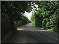
Lewes Road
Once the A275 but downgraded to the C7 in the late 1970s when new road systems at Lewes and Newhaven rerouted the port traffic up the eastern side of the Ouse valley. The entrance to Piddinghoe Mead is on the immediate left a new estate built in the grounds of the former Newhaven Isolation Hospital.
Image: © Simon Carey
Taken: 2 Jun 2012
0.08 miles
4
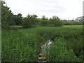
Drain, Riverside Park
A new public open space has recently been opened at the northern end of Newhaven on a former council refuse landfill site. This section is near the entrance from Lewes Road and is viewed from a footbridge.
Image: © Simon Carey
Taken: 16 Jun 2012
0.09 miles
5
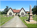
Newhaven Cemetery
Newhaven Cemetery was founded in 1885 by the “Local Board” and slopes uphill from Lewes Road. The pink column on the right is the Auxiliary Patrol Memorial, erected after the First World War by officers, petty officers and men of HM Auxiliary Patrol operating from Newhaven as a lasting tribute to their fallen comrades. One face of the memorial is sacred to the memory of the officers and men who were killed when HMT Borneo was blown up off Beachy Head during mine sweeping operations on 18th June 1917.
A very full history can be seen at https://www.newhaventowncouncil.gov.uk/town-council-services/newhaven-cemetery/
Image: © Marathon
Taken: 5 Jun 2021
0.10 miles
6
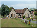
Cemetery chapels, Newhaven
Beyond is the narrow and not very conspicuous entrance from Lewes Road.
Image: © Robin Webster
Taken: 26 Jun 2013
0.10 miles
7
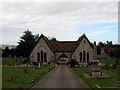
Chapel, Newhaven Town Cemetery
Built in 1885. The Auxiliary Patrol Memorial on the right is dedicated to those who lost their lives serving on the auxiliary patrol that was based in Newhaven during the First World War.
Image: © Simon Carey
Taken: 16 Jun 2012
0.11 miles
8
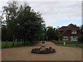
Sculpture, Newhaven Town Cemetery
Located at the entrance onto Lewes Road it is by Reginald Goulden and is identical to the one he produced for Dover War Memorial, see Image Goulden is buried in the cemetery.
Image: © Simon Carey
Taken: 16 Jun 2012
0.11 miles
9

Under the Nore (1)
The name of the field according to Newhaven's 1841 tithe map and mainly refers to the land on the slopes of Nore Down. Bollen's Bush is to the right. See Image for the opposite view.
Image: © Simon Carey
Taken: 31 Aug 2012
0.11 miles
10

Under the Nore (2)
The opposite view of Image Nore Down is to the left whilst on the right in the distance is Piddinghoe Pond and beyond that the lower Ouse valley with Itford Hill prominent.
Image: © Simon Carey
Taken: 31 Aug 2012
0.12 miles