IMAGES TAKEN NEAR TO
Woods Way, WORTHING, BN99 6HG
Introduction
This page details the photographs taken nearby to Woods Way, BN99 6HG by members of the Geograph project.
The Geograph project started in 2005 with the aim of publishing, organising and preserving representative images for every square kilometre of Great Britain, Ireland and the Isle of Man.

There are currently over 7.5m images from over14,400 individuals and you can help contribute to the project by visiting https://www.geograph.org.uk
Image Map
Images are licensed for reuse under creativecommons.org/licenses/by-sa/2.0
Notes
- Clicking on the map will re-center to the selected point.
- The higher the marker number, the further away the image location is from the centre of the postcode.
Image Listing (18 Images Found)
Images are licensed for reuse under creativecommons.org/licenses/by-sa/2.0
Image
Details
Distance
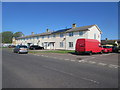
1
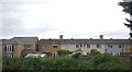
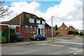
Terraced houses, The Quadrant, Durrington on Sea
Image: © N Chadwick
Taken: 8 May 2011
0.06 miles
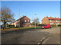
3
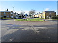
Traffic calming roundabout
In The Strand at junction with Maybridge Crescent (to the north) and The Quadrant (to the South).
Image: © Peter Holmes
Taken: 23 Feb 2015
0.11 miles
4
Traffic calming roundabout
In The Strand at junction with Maybridge Crescent (to the north) and The Quadrant (to the South).
Image: © Peter Holmes
Taken: 23 Feb 2015
0.14 miles
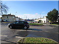
5
The Strand at junction with Grenville Avenue
Edge of the Maybridge Estate.
Image: © Peter Holmes
Taken: 2 Nov 2015
0.16 miles
6
Solar Power
The Strand at junction with Alexandra Court.
Image: © Peter Holmes
Taken: 27 Apr 2015
0.18 miles
7
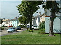
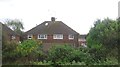
Durrington Housing, Maybridge Crescent
Typical Durrington housing just north of the railway near The Strand.
Image: © Chris Shaw
Taken: 17 Jun 2005
0.18 miles
8
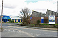
Goring Business Park
The list of businesses seems more industrial than "business" business, including the awe inspiring "Applied Kilovolts"!
Image: © Robin Webster
Taken: 26 Feb 2010
0.19 miles
9
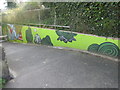
Urban Graffiti
Limbrick Lane pedestrian underpass, with National Rail oval bridge plate, BLI1/464B 12m 60ch.
Image: © Peter Holmes
Taken: 16 Apr 2015
0.20 miles
10
Goring Conservative Club
The lamp-post has a Conservative tendency!
Image: © Robin Webster
Taken: 26 Feb 2010
0.21 miles