IMAGES TAKEN NEAR TO
Heighton Road, NEWHAVEN, BN9 0JT
Introduction
This page details the photographs taken nearby to Heighton Road, BN9 0JT by members of the Geograph project.
The Geograph project started in 2005 with the aim of publishing, organising and preserving representative images for every square kilometre of Great Britain, Ireland and the Isle of Man.

There are currently over 7.5m images from over14,400 individuals and you can help contribute to the project by visiting https://www.geograph.org.uk
Image Map (Loading...)


Getting Data...Please wait
Leaflet Map data © OpenStreetMap
Images are licensed for reuse under creativecommons.org/licenses/by-sa/2.0
Notes
- Clicking on the map will re-center to the selected point.
- The higher the marker number, the further away the image location is from the centre of the postcode.
Image Listing (84 Images Found)
Images are licensed for reuse under creativecommons.org/licenses/by-sa/2.0
Image
Details
Distance
1
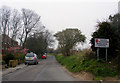
Heighton Road, entrance to South Heighton from Denton
Image: © Kevin Gordon
Taken: 14 Mar 2008
0.06 miles
2
Path from Forward Close to Iveagh Crescent
Footpath South Heighton 15 passes an electricity substation.
Image: © Robin Webster
Taken: 2 Dec 2011
0.07 miles
3
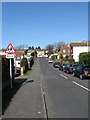
Acacia Road
Residential street in the suburb of Denton linking Denton Road with Denton Rise. It was marked out on a 1937 map but only had two cottages, those up the hill on the right, built on it at the time. Much of the rest was added in the postwar period.
Image: © Simon Carey
Taken: 21 Feb 2009
0.07 miles

5
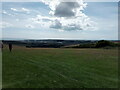
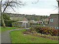
View over Newhaven from Beddingham Hill
Looking south-southwest.
Image: © Robert Lamb
Taken: 29 Aug 2022
0.08 miles
6
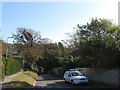
Heighton Road
Its narrowness and pronounced holloway give clues that this is the old road that linked South Heighton to Denton.
Image: © Simon Carey
Taken: 22 Oct 2011
0.09 miles
7
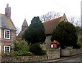
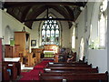
St Leonard's Church, Denton, Newhaven
A small but interesting church off the beaten track - I was the first to sign the visitor book for nearly four months. The building on the left is the Manor House.
Image: © Kevin Gordon
Taken: 14 Mar 2008
0.10 miles
8

Rectory Road
Linking Heighton Road to Denton Road and often used as an alternative route to Image as the road is wider. Originally laid out in the first decade of the 20th century as both Denton and South Heighton began to be built up in the wake of the development of Newhaven as a port. The Flying Fish public house is at the bottom of the road.
Image: © Simon Carey
Taken: 22 Oct 2011
0.10 miles
9
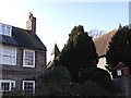
The manor house and church, Denton, East Sussex
Image: © nick macneill
Taken: 3 Feb 2011
0.10 miles