IMAGES TAKEN NEAR TO
Firle, LEWES, BN8 6NL
Introduction
This page details the photographs taken nearby to BN8 6NL by members of the Geograph project.
The Geograph project started in 2005 with the aim of publishing, organising and preserving representative images for every square kilometre of Great Britain, Ireland and the Isle of Man.

There are currently over 7.5m images from over14,400 individuals and you can help contribute to the project by visiting https://www.geograph.org.uk
Image Map
Images are licensed for reuse under creativecommons.org/licenses/by-sa/2.0
Notes
- Clicking on the map will re-center to the selected point.
- The higher the marker number, the further away the image location is from the centre of the postcode.
Image Listing (25 Images Found)
Images are licensed for reuse under creativecommons.org/licenses/by-sa/2.0
Image
Details
Distance
1
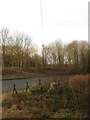
Medieval Cross near Middle Farm
A winter view of Image Looking at old maps it seems that the cross was moved to this position when the new course of the A27 was constructed during the 1960s, its old position was roughly where a bus stop and layby is located. The cross lies at an old crossroads where the east-west route from West Firle to Selmeston crossed the old droving road that is now Heighton Street and the lane to Ripe. Burgh Lane is the road in view with the A27 beyond the bank and trees to the left.
Image: © Simon Carey
Taken: 24 Dec 2011
0.05 miles
2
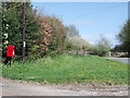
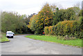
Postbox and verge near Middle Farm, Firle, East Sussex
Image: © nick macneill
Taken: 30 Apr 2010
0.05 miles
3
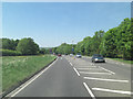
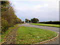
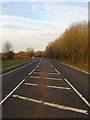
A27 Lewes Road approaches junction with Burgh Lane
Firle Road also joins the A27 at this point.
Image: © Stuart Logan
Taken: 27 May 2012
0.05 miles
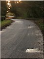
5
Burgh Lane, Firle.
This lane is just off the A27 near Firle. The remains of an ancient cross can be seen on the right.
Image: © Kevin Gordon
Taken: 2 Nov 2008
0.09 miles
6
Burgh Lane
Looking towards the old crossroads at Stamford Pound. The lane was the A27 until it was straightened in the 1960s.
Image: © Simon Carey
Taken: 24 Dec 2011
0.09 miles
7
A27 near Middle Farm, Firle
Middle Farm is in the distance on the corner. Picture taken from near Burgh Buildings.
Image: © Kevin Gordon
Taken: 2 Nov 2008
0.11 miles
8
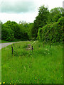
Remains of a Cross, near Firle
The road behind is Burgh Lane formerly the A27 until the road was straightened in the 1960s. I have no idea who erected the cross or how long it has stood, though much of the land to the immediate north of the South Downs in this area was once owned by Battle Abbey.
Image: © Simon Carey
Taken: 30 May 2006
0.12 miles
9
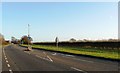
Firle Straight
The start of the section of the A27 known locally as Firle Straight begins from this point and continues up to the junction with the lane to West Firle. This road was constructed in the 1960s replacing the old narrow and winding Burgh Lane and Wick Street and necessitated the demolition of an old lodge that lay at the entrance to Heighton Street which is currently visible to the left. Mount Caburn is just visible through the trees.
Image: © Simon Carey
Taken: 24 Dec 2011
0.14 miles
10
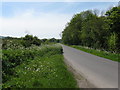
West along Firle Road
Adder Wells is the wood on the right.
Image: © Dave Spicer
Taken: 19 May 2012
0.16 miles