IMAGES TAKEN NEAR TO
Buttsfield Lane, LEWES, BN8 6EF
Introduction
This page details the photographs taken nearby to Buttsfield Lane, BN8 6EF by members of the Geograph project.
The Geograph project started in 2005 with the aim of publishing, organising and preserving representative images for every square kilometre of Great Britain, Ireland and the Isle of Man.

There are currently over 7.5m images from over14,400 individuals and you can help contribute to the project by visiting https://www.geograph.org.uk
Image Map
Images are licensed for reuse under creativecommons.org/licenses/by-sa/2.0
Notes
- Clicking on the map will re-center to the selected point.
- The higher the marker number, the further away the image location is from the centre of the postcode.
Image Listing (197 Images Found)
Images are licensed for reuse under creativecommons.org/licenses/by-sa/2.0
Image
Details
Distance
1
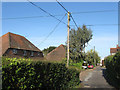
Buttsfield Lane
The lane follows an old footpath that once formed a field boundary between two fields called The Butts and Image
Image: © Simon Carey
Taken: 10 Apr 2012
0.02 miles
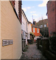
2
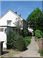
Cider House Walk
The view of the path from its junction with Buttsfield Lane. The cottages on the right date from the 18th century and once looked out over the village green and pond, both of which have long been built over.
Image: © Simon Carey
Taken: 27 May 2012
0.03 miles
3
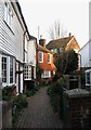
Cider House Walk
Small alley linking High Street to Buttsfield Lane. The cottages here date from the 18th century and once looked out over the old village green and pond.
Image: © Simon Carey
Taken: 1 Apr 2012
0.03 miles

5
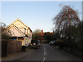
Buttsfield Lane
Small dead end lane heading off High Street. The tile hung house is the Old Post Office Cottage which dates from the 17th century and was the village post office during the 19th.
Image: © Simon Carey
Taken: 1 Apr 2012
0.04 miles
7
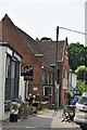
High Street
Very much the core of the old village with the white building and The Manse, a former methodist chapel, occupying the spot where the old village green and pond stood. There are still a couple of shops including a post office, hairdressers, second hand book shop and cafe making the most of the quieter backwater this road has become since the bypass was built back in A22. Prior to that heavy lorries had negotiate a 90 degree bend in the road.
Image: © Simon Carey
Taken: 24 Mar 2012
0.05 miles
8
Cider House Walk, East Hoathly
This twitten runs East from the High Street close to the Kings Head Pub.
Image: © Kevin Gordon
Taken: 11 Feb 2009
0.05 miles
9
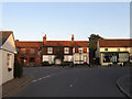
Central East Hoathly
The point where London Road in the foreground meets Wladron Road on the left and High Street to the right. Up to 1992 the ninety degree bend was part of the A22 and was often congested as large lorries had problems negotiating the corner. All this was alleviated by the construction of Image which has turned the road into a backwater and made the centre of the village a far more pleasant place. To the left is the Kings Head one of two village pubs which is also a microbrewery, whilst the village retains a few shops, in this case a second hand bookshop, a cafe and out of shop a hairdressers all located opposite the post office and general stores.
Image: © Simon Carey
Taken: 1 Apr 2012
0.05 miles
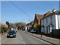
10

The Village Hair Shop, High Street East Hoathly
Formerly the A22 before the bypass was built. Bet they didn't park on the bend then.
Image: © Dave Spicer
Taken: 15 Aug 2010
0.05 miles