IMAGES TAKEN NEAR TO
Ranscombe Lane, LEWES, BN8 6AA
Introduction
This page details the photographs taken nearby to Ranscombe Lane, BN8 6AA by members of the Geograph project.
The Geograph project started in 2005 with the aim of publishing, organising and preserving representative images for every square kilometre of Great Britain, Ireland and the Isle of Man.

There are currently over 7.5m images from over14,400 individuals and you can help contribute to the project by visiting https://www.geograph.org.uk
Image Map
Images are licensed for reuse under creativecommons.org/licenses/by-sa/2.0
Notes
- Clicking on the map will re-center to the selected point.
- The higher the marker number, the further away the image location is from the centre of the postcode.
Image Listing (49 Images Found)
Images are licensed for reuse under creativecommons.org/licenses/by-sa/2.0
Image
Details
Distance
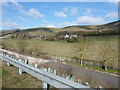
1

Ranscombe Cottages
Taken from the A27 with Mount Caburn providing the backdrop.
Image: © Simon Carey
Taken: 20 Sep 2008
0.02 miles
2
Houses on Ranscombe Lane
The concrete road passes under the A27 is for farm traffic to and from Beddingham.
Image: © Dave Spicer
Taken: 26 Feb 2012
0.02 miles
3

Road to Glynde outside Ranscombe Farm, East Sussex
The farm now has a very nice tea room and garden.
Image: © nick macneill
Taken: 23 Apr 2010
0.02 miles


6

Ranscombe Cottages
A set of 19th century cottages lying on Ranscombe Lane near to Ranscombe Farm.
Image: © Simon Carey
Taken: 20 Oct 2011
0.04 miles

8

Ranscombe House
Close to the A27 on the southern flank of Mount Caburn.
The site is shown on the OS as Ranscombe Farm, and this must have been the farmhouse. Most of the farmyard buildings now seem to have been demolished, and Ranscombe House advertises bed -and-breakfast accommodation.
Image: © Stefan Czapski
Taken: 28 Sep 2019
0.05 miles
9

Lewes Castle
View from the top of the South Tower towards Firle Beacon.
Image: © Michael Garlick
Taken: 12 Mar 2015
0.05 miles
10

Ranscombe House
Formerly Ranscombe Farm and dating from the 18th century though there seems to have been a farm on this spot since the Norman era. Not sure how much farming goes on now as all of the outbuildings to the rear have been turned into self catering holiday cottages known as Caburn Cottages and another has been turned into a tea room which appears to only be open during the summer months. Another former farm building is now occupied by a plumber and is located next to the parked cars in the distance.
Image: © Simon Carey
Taken: 20 Oct 2011
0.05 miles