IMAGES TAKEN NEAR TO
Ham Lane, LEWES, BN8 5SE
Introduction
This page details the photographs taken nearby to Ham Lane, BN8 5SE by members of the Geograph project.
The Geograph project started in 2005 with the aim of publishing, organising and preserving representative images for every square kilometre of Great Britain, Ireland and the Isle of Man.

There are currently over 7.5m images from over14,400 individuals and you can help contribute to the project by visiting https://www.geograph.org.uk
Image Map
Images are licensed for reuse under creativecommons.org/licenses/by-sa/2.0
Notes
- Clicking on the map will re-center to the selected point.
- The higher the marker number, the further away the image location is from the centre of the postcode.
Image Listing (19 Images Found)
Images are licensed for reuse under creativecommons.org/licenses/by-sa/2.0
Image
Details
Distance
1
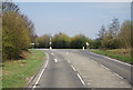
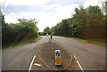
Ham Lane, near Ringmer
Ham Lane is a minor road near Ringmer, in East Sussex. The sign beyond the bend in the road indicates that the road is approaching its junction with the main A26 road.
Image: © Malc McDonald
Taken: 29 Aug 2022
0.04 miles
2
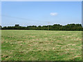
Footway Field
The name of the field according to the 1839 tithe map. The name probably derives from an ancient public access route through the fields which still exists today as part of a footpath from Ham Lane to the A26 near The Cock. Ham Farm is in the distance.
Image: © Simon Carey
Taken: 8 Aug 2009
0.08 miles
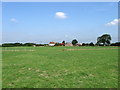
3
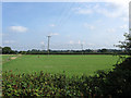
Great Field
The name given to the field by the 1839 tithe map. A very large field, hence the name that stretched over the north and west of Ham Farm. This portion belongs to the latter but has lost some of the land to the A26 when it was straightened in the 1990s, the current course of the road is beyond the hedge at the end of the field.
Image: © Simon Carey
Taken: 8 Aug 2009
0.11 miles
4
Lodge Field
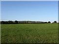
The name given to the field according to the 1839 tithe map. Clay Hill can be seen in the distance.
Image: © Simon Carey
Taken: 8 Aug 2009
0.11 miles
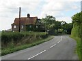
5
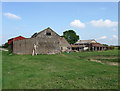
Outbuildings, Ham Farm
In various states of disrepair though there is evidence of some work going on. The farm was actually owned by East Sussex Council until it was sold in 2007 in three separate lots, farmhouse, outbuildings and land.
Image: © Simon Carey
Taken: 8 Aug 2009
0.13 miles
7
Great Field
The name given to the field according to the 1839 tithe map. The chalkpit scarred northern side of Malling Hill can be seen in the distance.
Image: © Simon Carey
Taken: 25 Jul 2009
0.16 miles
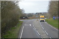
8
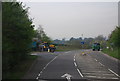
Ham Lane junction with the A26 near Ringmer
Image: © N Chadwick
Taken: 29 Apr 2010
0.16 miles