IMAGES TAKEN NEAR TO
Corner Green, LEWES, BN8 5PS
Introduction
This page details the photographs taken nearby to Corner Green, BN8 5PS by members of the Geograph project.
The Geograph project started in 2005 with the aim of publishing, organising and preserving representative images for every square kilometre of Great Britain, Ireland and the Isle of Man.

There are currently over 7.5m images from over14,400 individuals and you can help contribute to the project by visiting https://www.geograph.org.uk
Image Map
Images are licensed for reuse under creativecommons.org/licenses/by-sa/2.0
Notes
- Clicking on the map will re-center to the selected point.
- The higher the marker number, the further away the image location is from the centre of the postcode.
Image Listing (132 Images Found)
Images are licensed for reuse under creativecommons.org/licenses/by-sa/2.0
Image
Details
Distance
1
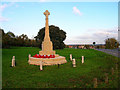
War memorial, Ringmer
Looking east along the village green and B2192. Ringmer was not originally the principal village of the area but a common for the farmers of Rushy Green, Ashton Green, Norlington and Wellingham to graze their livestock on. However, Ringmer soon became the parochial centre, and from the enclosures onwards the village grew, particularly after two turnpikes (nowadays the B2192 and B2124) were driven through the common in the 1740s. Now it's the principal village and the others have become small sleepy hamlets.
Image: © Simon Carey
Taken: 13 Nov 2005
0.01 miles
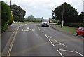
3
Old Direction Sign - Signpost by the B2192, Lewes Road, Ringmer parish
Black iron cap finial - 2 arms; East Sussex wood with number by the B2192, in parish of Ringmer (Lewes District), B2192 Lewes Road, on wide verge opposite junction with Church Hill - by village pump.
Surveyed
Milestone Society National ID: SX_TQ4412A
Image: © Milestone Society
Taken: Unknown
0.03 miles
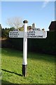
4

Church Villas
At the junction of Church Crescent (left) and Vicarage Way (right) a one way system meeting to form Church Hill then Ham Lane which then heads towards the A26.
Image: © Simon Carey
Taken: 2 Aug 2009
0.03 miles
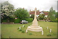
6
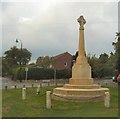
Ringmer War Memorial
Names of the Men of Ringmer Commemorated on the War Memorial can be found at http://www.ringmer.info/war-memorial.html
Image: © Paul Gillett
Taken: 10 Sep 2011
0.04 miles


10

Church of St Mary the Virgin, Ringmer
Image: © Paul Gillett
Taken: 10 Sep 2011
0.05 miles