IMAGES TAKEN NEAR TO
Broyle Lane, LEWES, BN8 5AB
Introduction
This page details the photographs taken nearby to Broyle Lane, BN8 5AB by members of the Geograph project.
The Geograph project started in 2005 with the aim of publishing, organising and preserving representative images for every square kilometre of Great Britain, Ireland and the Isle of Man.

There are currently over 7.5m images from over14,400 individuals and you can help contribute to the project by visiting https://www.geograph.org.uk
Image Map
Images are licensed for reuse under creativecommons.org/licenses/by-sa/2.0
Notes
- Clicking on the map will re-center to the selected point.
- The higher the marker number, the further away the image location is from the centre of the postcode.
Image Listing (25 Images Found)
Images are licensed for reuse under creativecommons.org/licenses/by-sa/2.0
Image
Details
Distance
1
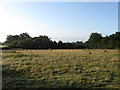
Middle Meadow
The name of the field according to the 1839 tithe map. The footpath from Norlington Lane to Broyle Lane also runs through it.
Image: © Simon Carey
Taken: 2 Aug 2009
0.13 miles
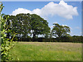
2
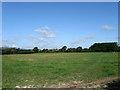
Five Acres
The name of the field according to the 1839 tithe map. Taken from the footpath that links Little Norlington to Broyle Side.
Image: © Simon Carey
Taken: 25 Jul 2009
0.14 miles
3
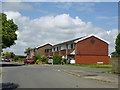
Houses on Broyle Lane
The last houses in the residential area of Broyle Side.
Image: © Robin Webster
Taken: 16 Jun 2012
0.15 miles
4
Barn Plot
The name of this small field according to the 1839 tithe map. The plot originally ran north of the footpath though has now been split in two demarcated by a hedge.
Image: © Simon Carey
Taken: 25 Jul 2009
0.15 miles
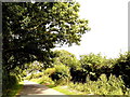
5
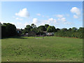
Field by Norlington Lane
Looking behind the hedge along the lane, on the near left, at a hedgerow running at right angles to the lane.
Image: © Robin Webster
Taken: 16 Jun 2012
0.16 miles

7
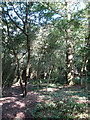
Small Wood near Howell's Bank Farm
Containing the footpath that links Little Norlington with Broyle Side.
Image: © Simon Carey
Taken: 25 Jul 2009
0.16 miles
8
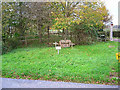
Soldiers Graves, Green Lane
The plaque reads 'These are the graves of two soldiers who died in a duel circa 1800'. Difficult to ascertain which square this is in as it lies right on the border with TQ4614, the graves are opposite the junction of Green Lane, Norlington Lane and Broyle Lane with the drive to Plashett Park Farm heading north behind them.
Image: © Simon Carey
Taken: 13 Nov 2005
0.17 miles
9
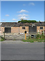
Careys Cowshed, Broyle Lane
Not belonging to me though. Looks like they are used as stables.
Image: © Simon Carey
Taken: 25 Jul 2009
0.17 miles
10
Norlington Lane, Little Norlington, East Sussex (2)
Image: © nick macneill
Taken: 19 Aug 2011
0.18 miles