IMAGES TAKEN NEAR TO
South Chailey, LEWES, BN8 4AS
Introduction
This page details the photographs taken nearby to BN8 4AS by members of the Geograph project.
The Geograph project started in 2005 with the aim of publishing, organising and preserving representative images for every square kilometre of Great Britain, Ireland and the Isle of Man.

There are currently over 7.5m images from over14,400 individuals and you can help contribute to the project by visiting https://www.geograph.org.uk
Image Map
Images are licensed for reuse under creativecommons.org/licenses/by-sa/2.0
Notes
- Clicking on the map will re-center to the selected point.
- The higher the marker number, the further away the image location is from the centre of the postcode.
Image Listing (30 Images Found)
Images are licensed for reuse under creativecommons.org/licenses/by-sa/2.0
Image
Details
Distance
1
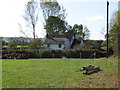
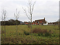
Old Barns Farm
Some of the dwellings, part of Old Barns Farm
Image: © Peter Whitcomb
Taken: 18 Oct 2009
0.02 miles
2
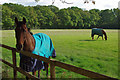
Hopeful horse
Of the two horses in this field, one was happy to graze, but the other was hopeful of something more exciting than grass.
Image: © Robin Webster
Taken: 19 Oct 2010
0.04 miles
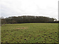
3
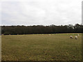
House Field
The name of the field according to the 1838 tithe map with Swan Wood in the background.
Image: © Simon Carey
Taken: 2 Jan 2011
0.07 miles
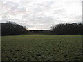
5
Drapers Wood Field
The name of the field according to the 1838 tithe map with Drapers Wood to the left.
Image: © Simon Carey
Taken: 2 Jan 2011
0.10 miles
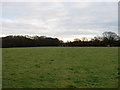
6
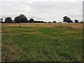
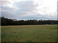
Two Acres
The name of the field according to the 1838 tithe map with Oldbarns Wood at the eastern end.
Image: © Simon Carey
Taken: 2 Jan 2011
0.10 miles
7
Pond Field
The name of the field according to the 1838 tithe map with the titular pond amongst the trees to the right.
Image: © Simon Carey
Taken: 2 Jan 2011
0.12 miles
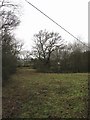
8
Pit Field
The name of the field according to the 1838 tithe map. Beyond is the rear view of Swan House a former inn that was plying its trade as early as 1606. on the old medieval road from Lewes to London at the southern edge of the former South Common.
Image: © Simon Carey
Taken: 2 Jan 2011
0.14 miles
9
Furze Field
The name of the field according to the 1838 tithe map. The field has been cut out of Drapers Wood which still surrounds it.
Image: © Simon Carey
Taken: 2 Jan 2011
0.15 miles
10
Twelve Acres
The name of the field according to the 1838 tithe map that has been expanded to include Image to the west. Old barns Wood is at the far end of the field.
Image: © Simon Carey
Taken: 2 Jan 2011
0.16 miles